> From the WeatherWatch archives
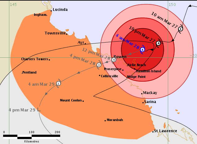
Cyclone Debbie remains a powerful Category 4 tropical cyclone and it likely to be this strength and category as it makes landfall in Queensland this afternoon.
There are a number of populated places exposed to the damaging winds, which includes Hamilton Island the Whitsundays and Bowen, where the low may make landfall. However the current track does places the worst of the wind and rain south of the city of Townsville.
Australian forecasters estimate Debbie will make landfall generally around 12noon Australian time, so around 2 to 3pm NZT.

12:40pm Bowen Rain Radar from BoM
The storm is a major one for the history books and once it makes landfall today it will start to rapidly unwind. “As soon as Debbie makes landfall the storm will start to fall apart but the storm surge will be significant with this Category 4 storm acting like a giant vacuum and lifting the level of the sea by metres as it moves in. On top of that storm surge the powerful winds up to 250km/h or more is creating waves of almost 8 metres” says WeatherWatch.co.nz head weather analyst Philip Duncan. “These intense winds will also destroy homes and bring the sea further inland through these populated tourist areas. Damage may be catastrophic” says Duncan.
“By tonight and into Wednesday Debbie will start to lose it’s worst winds and then it becomes a major rain and flood event for parts of Queensland dumping over half a metre, or 500mm, of rain across parts of the state”.
Mr Duncan says Hamilton Island currently (12:47am NZT) has winds well over 200km/h and it’s still rising.
Debbie will likely lose its cyclone status on Wednesday most likely and then the rain becomes the main focus as the winds start to ease slowly.
Meanwhile the leftovers of Debbie may help encourage more tropical downpours around New Zealand in the first several days of April. It’s complicated and focus at this stage should remain on Queensland, but there are some signs that the remnants of Debbie will drift out into the Tasman Sea this weekend and perhaps affect New Zealand.
We’ll be tracking Debbie today, check back for more updates.


– Images above BOM
– Image below Weatherzone

– WeatherWatch.co.nz
Comments
Before you add a new comment, take note this story was published on 27 Mar 2017.


Add new comment