Auckland’s windy summer may get even windier – we explain what’s going on
29/12/2019 2:25am

> From the WeatherWatch archives
After a hot start to December Auckland is now dealing with a cooler sou’west flow which looks set to ramp up further in January.
WeatherWatch.co.nz says high pressure over Australia plus the the northern and western sides of the Tasman Sea coupled with lows in the Southern Ocean are pushing westerly quarter winds over the country. This is helping produce some very sunny weather in the east but it’s also pushing cooler air into the west. It’s not just Auckland that is windy either, Canterbury has had a run of windy nor’westers this month. But Auckland is in a particularly windy phase going into the first week of January at least.
While Auckland has had some cooler than average days, it has also had a run of normal to above normal temperatures too. The wind makes the air feel cooler than it is – so sheltered areas are hotter. Also, burn times and UV rays are still high regardless of how hot you feel.
Calmer weather this summer is lying to NZ’s east and is contributing to a Texas-size area of ‘hot’ sea water there. The past couple of summers had calmer weather over on the Tasman Sea side instead, which lead to a marine heatwave in the NZ area and to our west – as a result Auckland didn’t receive such windy sou’westers. This flow makes for drier weather but more average temperatures with fewer of the truly hot days over 25 degrees. Hottest weather will be inland areas leaning east across both the rural north and south of the region.
Why is New Zealand so windy? We explain the Roaring Forties here
To be honest, this windy set up is basically a default setting for narrow Auckland – but the current set up is windier than usual and will continue plus tick up a notch into January as high pressure over drought stricken Australia stays put and storms in the Southern Ocean continue to track past to NZ’s south. This sees windier weather through the usual parts of the country – including our most populated region.
Auckland is one of three main wind tunnels in New Zealand – you can see more about it here. This windy weather will also affect surrounding regions like coastal Waikato, coastal Northland and Coromandel Peninsula.
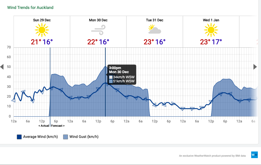
Those checking local forecasts in Auckland will notice wind symbols in January.
For campers it’s one step forward and one step backward. The windy weather can become highly frustrating for those in tents and with awnings, or beachgoers with sun umbrellas – but the set up is also keeping the skies mostly dry with only the odd brief shower. It also encourages sunnier skies in our more populated upper North Island beaches.
If you want to drill down further our new website RuralWeather.co.nz has more wind and weather data for your specific location than any other website. Please note, it currently takes 10 seconds to load up the data when you first log on (we are speeding this up in the near future). This also shows in graph form the average winds and the days with strong gusts – as per the images below:
Next Friday January 3 shows the windy sou’west flow
*WeatherWatch.co.nz will be releasing our January outlook and updated 3 month climate/seasonal outlook before New Year’s Eve.
– WeatherWatch.co.nz
Comments
Before you add a new comment, take note this story was published on 29 Dec 2019.


Add new comment