A changing scene – Your Weather Highlights for the next 3 days
4/05/2016 7:00pm

> From the WeatherWatch archives
Your warm May continues, though there is rain, showers and strong winds in the forecast for the coming few days – autumn certainly hasn’t been boring!
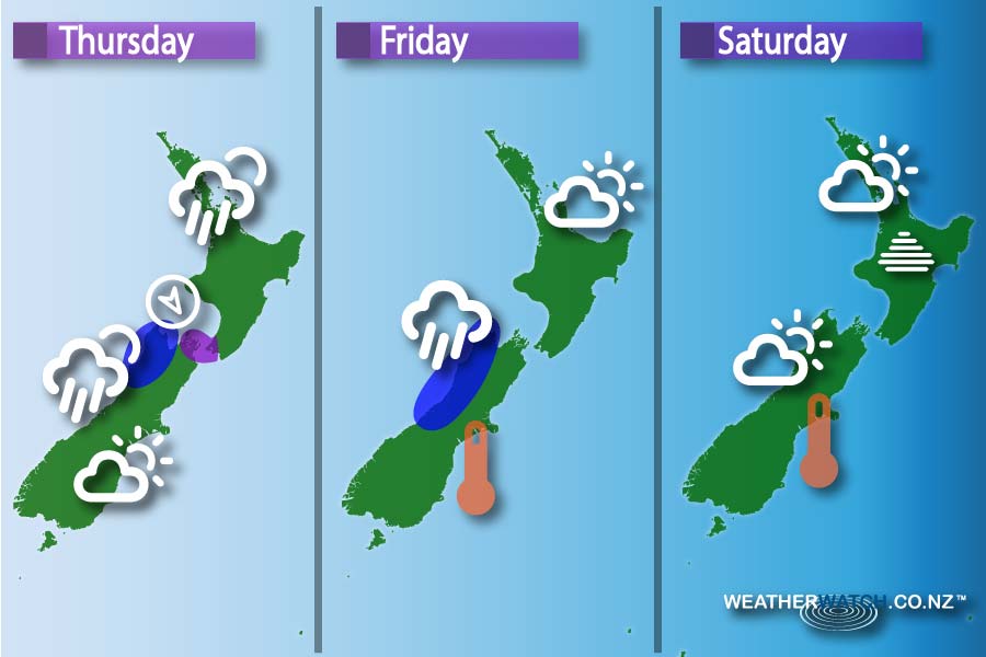
Thursday
A front continues to move over the North Island during the day, weakening but clinging on – and slowing down.
That means it could be wet in parts of the North Island, but nothing too serious.
Dark blue: Some early heavy rain about Buller falls before that front departs northwards, and clears.
Purple: Northwesterly winds through Cook Strait will be strong, with a low risk of gales then easing around lunchtime.
Friday
The front to the west of the South Island doesn’t seem to want to push onto land anymore, and while it will make landfall, it’s weakening more than our models suggested initially, so may not have too much bite left – while a northerly windflow returns to the South Island – meaning high temperatures are back.
Dark Blue: The West Coast looks cloudy and drizzly – with spells of rain or steady showers possible too.
Saturday
Some rain about Buller continues, along with a chance it may be heavy.
Fog & mist: There’s a chance of fog about inland North Island areas, during the morning and later in the evening too.
– Please note, the idea behind this update is to focus on the main weather highlights, so that’s why not all regions are mentioned.
For specific 10 day information for your city, town, rural community or island please see the 1000 forecasts on our homepage!
– Aaron Wilkinson & Drew Chappell, WeatherWatch.co.nz
Comments
Before you add a new comment, take note this story was published on 4 May 2016.
Latest Video
Another cold blast this weekend + Christmas Day weather
As we’ve been saying for several weeks now, we have a spring-like pattern going through December, but with summer-like temperatures….
Related Articles
Wintry change for some, windy and warm for others
A cold snap is moving up NZ today and Saturday, before easing Sunday and clearing most places on Monday –…
Another cold blast this weekend + Christmas Day weather
As we’ve been saying for several weeks now, we have a spring-like pattern going through December, but with summer-like temperatures….

Spring-like until Christmas (NZ’s 11 Day forecast!)
Severe gales, heavy West Coast rain, and temperature fluctuations are on the way as spring weather returns following a much…


Add new comment