200+ mm coming for the West Coast, a couple showers only for the east coast (+2 Maps)
10/07/2019 8:25pm

> From the WeatherWatch archives
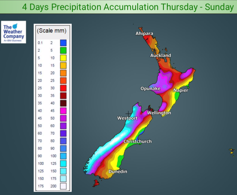
We have a number of fronts coming in to New Zealand over the next week and the West Coast is most exposed with rainfall totals quite high over the four days ahead.
Over 200mm is forecast between now and the end of Sunday on some parts of the West Coast, while further north into the North Island the totals are much lower, between 15mm and 60mm over the next four days.
But eastern NZ is especially dry in this new westerly set up, which sees over 90% of the rain falling on the western side of the country. Totals in the east are very low with just 0.2 to 5mm forecast between Dunedin and Gisborne.
Heavy snow will fall across the Southern Alps and the Central Plateau mountains with as much as 150cm (1.5m) of snow falling on the mountain tops in the south and some flurries making it down into the ski fields. Mt Ruapehu is only forecast to receive about 10cms of snow. Heavy snowfall totals like this also increase the Southern Alps avalanche risk.


– WeatherWatch.co.nz
Comments
Before you add a new comment, take note this story was published on 10 Jul 2019.


Add new comment