Where’s the Rain? We track forecast rainfall totals across NZ over the next 7 days (+4 Maps)
14/02/2019 2:21am

> From the WeatherWatch archives
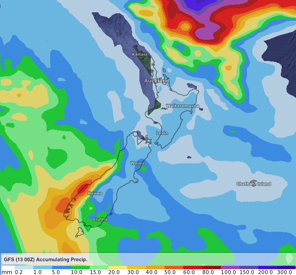
If you need rain here’s the latest on how much is coming and where it will likely (or not likely) be falling. With so much tropical unrest on our back door stop there are some large totals offshore, but over land high pressure is continuing to dominate this month and is holding a lot of rainmakers away from the North Island and upper/eastern South Island.
Below we have compared two main global weather models, GFS (US Government) and ECMWF (Europe) with their Total Accumulated Precipitation Maps…in other words, how much rain is coming to all parts of New Zealand over the next week. Both are saying a very similar thing.
We’ve broken it down into two outlooks, each with a second opinion, covering how much is expected from today, Thurs Feb 14, until midnight this coming Sunday Feb 17. Then another longer range look at total rainfall from today out for a full week, until midnight Thursday Feb 21st.
As for longer range (Beyond 1 week) we’re just waiting to firm up where Cyclone Oma might go – as the modelling isn’t quite sure just yet and neither is our gut instinct. With such heavy rain offshore it may give some people false hope – once we can lock that in we’ll provide a 14 day rainfall outlook too.
SHORT TERM 4 DAY RAINFALL (From Feb14 to midnight this Sunday)
GFS:
ECMWF (over the same period, to midnight this Sunday)
7 DAY TOTAL EXPECTED RAINFALL – from between now (Feb 14th) and midnight next Thursday (Feb 21st)
GFS:
ECMWF:
– WeatherWatch.co.nz
Comments
Before you add a new comment, take note this story was published on 14 Feb 2019.


Add new comment