> From the WeatherWatch archives
Another spring system is about to pounce and yet again rain is the main feature.
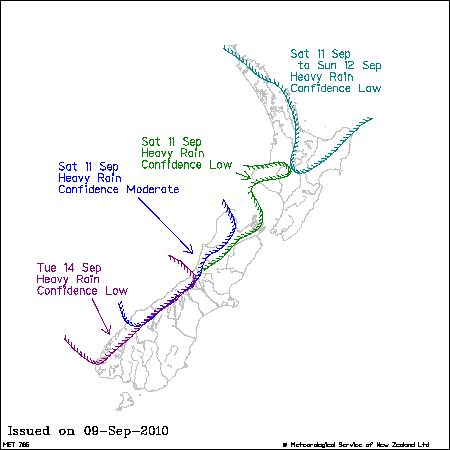
From top to bottom the west coast of New Zealand is in for a period of heavy rain starting during Saturday and easing on Sunday.
Most affected will be the West Coast of the South Island however pockets of the North Island will also be vulnerable from Bay of Plenty up to Northland and also including Mt Taranaki, Whanganui River catchment and possibly the Tararua Ranges – however a repeat of Monday’s flooding is not currently predicted.
The good news for those in Canterbury is that Saturday should be dry and Sunday is likely to only see a few spits of rain.
Eastern parts of the North Island are in for similar conditions.
The government forecaster has a severe weather watch in force – see the map for details.

Image: NZ Govt
Comments
Before you add a new comment, take note this story was published on 9 Sep 2010.


Add new comment
sw on 9/09/2010 9:37pm
Except for lengthening daylight,and a fine day here and there,it still is pretty much winter here,only the weeds are responding to it.
Reply