> From the WeatherWatch archives
Many in the upper North Island are desperate for rain while those in the South Island wonder how on earth ‘winter’ arrived so quickly after summer officially ended.
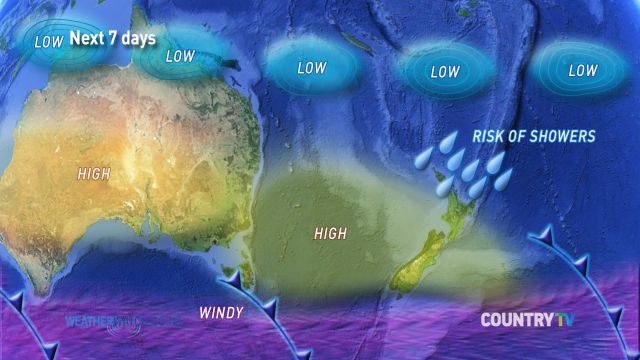
This graphic shows at a glance the set up around our part of the world over the next week or so. There is a stream of high pressure systems moving in from the west – this will help calm things down (and warm things up) over the next few more days.
The Southern Ocean is packed with gales and fronts – some of these will surge up into the South Island over the coming week bringing brief rain or showers and a surge in southerlies. But generally speaking we expect to see more high pressure rolling in from the west.
In the north a risk area for showers forms – but it certainly doesn’t promise rain for dry parts of the country. The risk area will be a welcome silver lining though.
Finally we end with the tropics – where a number of tropical lows and cyclones are expected this month, many well north of us posing no direct risk to New Zealand. However WeatherWatch.co.nz says for the dry conditions in the north to be truly reversed, a tropical or sub-tropical rain maker would be the key.

Graphic / WeatherWatch.co.nz & CountryTV
Comments
Before you add a new comment, take note this story was published on 5 Mar 2014.


Add new comment
Guest on 7/03/2014 8:18am
http://www.stormsurfing.com/cgi/display_alt.cgi?a=etoz_precip
Reply
WW Forecast Team on 7/03/2014 9:44pm
Yep – we have the latest on our homepage now
Cheers
WW
Reply