Updated: Rain & Snow Accumulation Maps for all NZ next two days & next week ahead (+9 Maps)
19/11/2018 8:27pm

> From the WeatherWatch archives
Rain is being welcome by many farmers and growers but more is needed in the North Island and more is coming. As a large low lingers over New Zealand until Thursday of this week it will bring heavy downpours with isolated thunder to the North Island today while South Islanders have more rain on the eastern side down towards Otago and Southland – falling as snow in the mountains.
Once this low clears away on Thursday PM the country will have a short breather before the next low rolls in, and this low looks much larger. The second low which begins moving in this weekend will cover the entire Tasman Sea area and will take until the middle of next week to clear New Zeland. Large doesn’t equal stormier – it simply means there will be larger areas of rain but also large dry areas too. Still a lot to work out about the weekend/early next week’s low so in the meantime our focus remains on the low currently over New Zealand and how much more rain is still to come.
Rain in the lower eastern South Island may break up today with dry and drizzly spells – but returns later today or tonight and will become heavy and set in for a time, easing back before dawn Wednesday at this stage. Another burst of lighter/moderate rain comes back later on Wednesday.
7 DAY RAINFALL FORECAST MAP COMPARED TO NORMAL…Blue = Wetter than average next week ahead, White = Normal rainfall, Red = Drier than normal. Data with big thanks to the US Government:


TOTAL PRECIPITATION ACCUMULATION IN ONE MAP FROM 1pm TUESDAY to MIDNIGHT WEDS (35 hours)
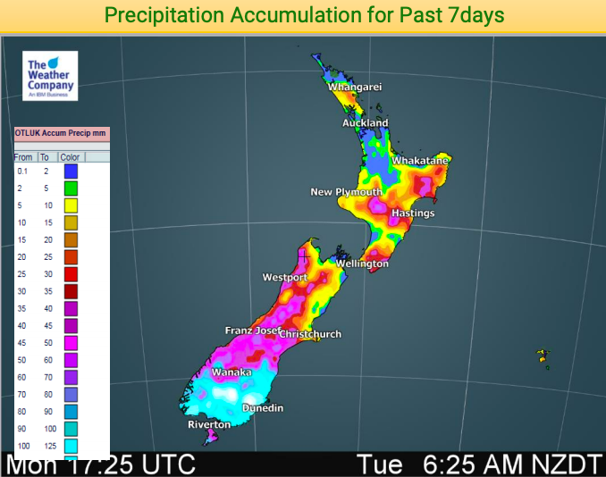
WHAT HAS FALLEN SO FAR? Here’s a look back at the last 7 days across New Zealand:

– WeatherWatch.co.nz
Comments
Before you add a new comment, take note this story was published on 19 Nov 2018.


Add new comment