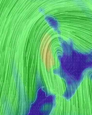
Update: Colder change moving into northern NZ with gales peaking tonight/overnight
10/04/2018 9:10am

> From the WeatherWatch archives
UPDATED 9:06pm — Colder air continues to move northwards this evening as the centre of the low causing the extra winds makes landfall in the western Waikato / South Auckland area. The public rain radar shows the centre moving in as of now/mid evening.
Winds will continue to peak as the centre of the low moves in this evening with the strongest of the winds being pulled in from the Tasman Sea as the low crosses the North Island tonight/overnight.
WeatherWatch.co.nz estimates the strongest winds will be in the south to south west change developing as the centre of the low makes landfall and tracks eastwards, allowing the much cooler southerly to spread northwards over the upper North Island.
Some gusts may be strong enough to cause some minor damage (trampolines blowing away, outdoor furniture blowing around etc), there may also be some trees and branches blown down which could add to the chances of power outages.
Around 2pm on Tuesday WeatherWatch.co.nz issued a special Gale Alert for Auckland warning of possible damage and power cuts this evening.
Winds should be peaking between now and the early hours of Wednesday morning in the upper North Island but a number of regions will be windy on Wednesday. Most will be cold too.
Mild air still remains over the upper North Island and mid teen temperatures are being recorded at the moment thanks to the westerly flow. Those further south with the southerly change are almost entirely in the single digits as of 9pm.
#Auckland Gales Alert: https://t.co/gb7E1qcpZ3 expects westerly gales to continue and may strengthen further this evening increasing the risk of power cuts and low end damage (eg, trampolines!). Winds turn colder SW overnight. pic.twitter.com/13lbHTcBBu
— WeatherWatch.co.nz (@WeatherWatchNZ) April 10, 2018
 – 9pm wind map showing the strongest winds in the south west to south change moving up and into the western North Island this evening / Earth.nullschool.net
 The centre of the low causing the gales is moving eastwards into the Waikato and South Auckland regions bringing a colder south to south west change behind it. Inforgraphic by WeatherWatch.co.nz using the Government owned, tax funded, rain radar as of 8:30pm.
– WeatherWatch.co.nz
Comments
Before you add a new comment, take note this story was published on 10 Apr 2018.


Add new comment
Nigel on 10/04/2018 10:47am
Lost power and fence is down due to really strong winds. Winds hitting the house and rumbling the ranch sliders.
Reply
Karl on 10/04/2018 9:48am
Hi.. the wind out west auckland is insane right now.. it’s hinge hitting the house.. can hear trees cracking and breaking..friends roof has come off.. Wild West right now
Reply
Alice on 10/04/2018 10:13am
Golly gosh! We’re in East Aucks right now and the wind is making some dreadful noise. Hopefully things don’t get too bad for you there, I really hope it doesn’t here too!
Reply