Tropical storm likely over NZ waters next week (+ Maps)
28/03/2012 9:30am

> From the WeatherWatch archives
Computer models are now in agreement that a tropical low will form this weekend about 2000kms north of New Zealand – then it will track towards the North Island, possibly strengthening into a severe tropical cyclone. However the models still remain unsure about the exact path it will take.
Head weather analyst Philip Duncan says the European models, which accurately predicted every one of the tropical cyclones last year, has been predicting since Sunday that this low will make a direct hit over northern New Zealand next week. “The problem with highly reliable models is that occasionally they do get it wrong – so rather than putting all our eggs into one basket, we monitor all the various computer models and so far they are still at odds over the exact path”.
But Mr Duncan says in the past 24 hours both the European and American models have agreed that this low will not only be very deep but it is very likely to have some impact on the North Island.
“At the very least we’re expecting strong to gusty winds from the easterly quarter and dangerous rips and surf along the entire eastern coastline of the North Island – and at the worst we’re looking at a direct hit from a nasty and slow moving tropical storm”.
“We’re not trying to alarm people but considering the three recent damaging lows which have brought wind damage, slips and flooding to the North Island we feel it’s important to give northerners an early heads up”.
WeatherWatch.co.nz said on Monday that confidence of the tropical low impacting New Zealand was around 20%. Today the weather news authority says it’s closer to 40% – still placing confidence in the low to moderate range. “This far out we can’t really have high confidence, especially when the models are still conflicted as to the exact path, but there is no harm in monitoring developments over the next few days”:.
The timing of the lows arrival near New Zealand is also still uncertain. “The various data we’ve looked at suggests it will be very slow moving, held up by the large high currently over New Zealand. It could arrive as early as Tuesday and linger as long as Good Friday”.
Mr Duncan says the predicted low is fairly normal for April. “People often joke about rough weather at Easter and for good reason – March and April often see lows coming out of the tropics and sub-tropics”.
What the international models are saying
- ECMWF (European) – Traditionally the most reliable for tropical storms in our view – shows easterlies building on Monday over the North Island with the low making landfall over the North Island late on Tuesday April 3rd and not clearing until Friday April 6th (Good Friday.
- GFS (American) – Still picking a nasty low which will track within 500kms of East Cape but remain off the North Island’s east coast next week.
- BOM (Australia’s government forecaster) – Suggests the low will be north of Bay of Plenty on Tuesday April 3rd bringing strong nor’easters and rain to the upper North Island.
The long range maps
ECMWF

Tuesday April 3rd – Green = strong to gale force winds. Yellow = brisk. Note there are two centres, one just north east of Northland, the other west of Northland in the Tasman. Sometimes large systems like this spread the energy further, which can reduce extreme wind speeds.
GFS

Tuesday April 3rd – Keep in mind this map is curved – so the low is actually more to the north of NZ and not to the extreme north east. In saying that, GFS does plot the low tracking to NZ’s north east beyond next Tuesday.
BOM

BOM has the low closer to NZ than GFS – with a new low forming in the Tasman. BOM seems to be halfway between ECMWF and GFS – which is what WeatherWatch.co.nz tends to support at this stage.
WEATHERMAP.CO.NZ

Wind and rain just offshore next Wednesday, April 4 — Our own internal maps, supplied by Weathermap.co.nz, use GFS data – so it’s not surprising that they also show the low to the north east of NZ. It’s possible that in the coming days this map will start to shift this low closer to NZ (based on what the other models are saying). But this is the million dollar question at this stage – which model will be the most accurate?

Potential sea swells – next Wednesday April 4th – Even if the storm fails to hit New Zealand, it’s still likely to drive in very big swells along the entire eastern coastline of the North Island. Swells of over 4 metres may be possible with the risk for dangerous rips and surf lingering into the long Easter weekend when holidaymakers will be heading to the beaches.
– WeatherWatch.co.nz exclusive
Comments
Before you add a new comment, take note this story was published on 28 Mar 2012.


Add new comment
MarineWeather on 28/03/2012 6:35pm
Thursday should see the swell peaking along the east coast, with the biggest waves in over a year:
http://www.marineweather.co.nz/forecasts/charts/gisborne
Reply
Kevin on 28/03/2012 9:54am
Hello,
Thank you for your constant and interest updates!
Im just wandering, if this “tropical storm” does indeed hit NZ, how would the strength be compared to previous Cyclones? (e.g. like Cyclone Wilma)
Thanks!!
Reply
WW Forecast Team on 28/03/2012 6:36pm
Hi – thanks for the email! This one has the potential to be worse than Wilma but the models remain at odds today (Thursday). The saving grace for NZ is that one model – GFS – has been constantly picking this low will track east of NZ. While ECMWF pick it directly hitting us. The most likely path will be in between these two models – but even then that takes it offshore for us. But because ECMWF still have it picked for a direct hit we have to really watch closely. Every tropical low is different…Wilma had a very deep air pressure – this one may too. So it brings the risk of both wind and rain damage – but like I say, as of this stage, it does seem to favour a slight easterly tracking from NZ. The next few days will be very important as the models solidify.
Cheers
Philip Duncan
Reply
Graeme on 28/03/2012 9:06am
I think you will find Adelaide and whangarei are about the same latitude.
Reply
Guest on 28/03/2012 6:36am
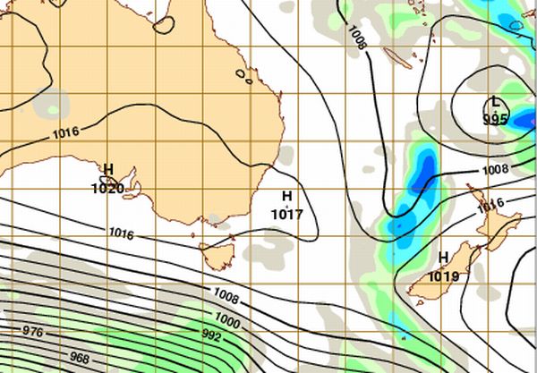
Although these maps are not accurate, what I always find interesting is those maps (TVNZ) that place the bottom of the South Island equal with the bottom of Tasmania. The bottom of the South Island is much further south than Tasmania and the two island do not line up equally.
These maps show a better true postioning of New Zealand.
Reply
Sue on 28/03/2012 5:16am
Cool. Im moving house then. Wouldnt you just know it. And I live in the East. In the North Island. Cool.
Reply
David on 28/03/2012 4:21am
Wow, something to be ready for next week then, just in case.
I guess we can blame the lazy high pressure system for slowing this thing down over us, maybe.
Cheers.
Reply