Thursday’s weather headlines (x3): Showers finally clear eastern NI, General rain outlook, Fog potential
30/03/2022 6:00pm

> From the WeatherWatch archives
Here’s what is making the weather headlines today.
SHOWERS FINALLY CLEAR EASTERN NORTH ISLAND
Yes the end is nigh for eastern North Island showers, they should mostly clear this afternoon but the odd straggler may remain till evening. So how can we tell the eastern North Island has been a bit wet apart from the obvious of experiencing it and seeing it, well we can turn to the “Soil moisture anomaly” map from NIWA. The one below was published at 9am yesterday morning. Certainly conditions are wet in the east.
Conversely we can see that the lower South Island and parts of the West Coast are drier than normal.

OUTLOOK FOR RAIN
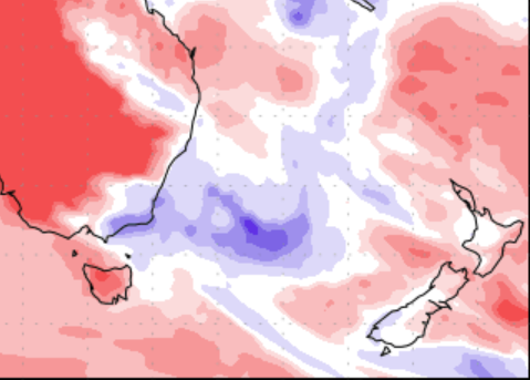
The next 7 days looks to see average rainfall for the West Coast, lower South Island and also parts of the western North Island. Fiordland is looking to be a touch wetter than normal. Elsewhere is looking a touch drier than normal but that’s not to say showers or some rain may push through at times. More on the exact timing of fronts and areas of rain or showers as we move forward here.
And below here is the “Precipitation percentage of normal” map through to Thursday 7th April. Red is drier than normal, blue is wetter than normal.

FOG POTENTIAL
This morning we see fog for the southeastern corner of the South Island and in the northwest (Nelson, Buller etc), especially inland away from the coast. Some inland parts of the North Island in the west see fog this morning too.
Tomorrow morning fog or low cloud is more strictly a story for the North Island with most regions likely to experience it, the South Island is fog free.
Below is a graph showing fog potential for Kaikohe in Northland, most nights for the next 5 days look to have a chance. For more on your location please visit RuralWeather.co.nz, use the search function then click on the “Fog/Cloud” tab.

Comments
Before you add a new comment, take note this story was published on 30 Mar 2022.


Add new comment