Thursday/Friday cool down coming – rain for dry regions too (+5 Maps)
23/10/2018 9:44pm

> From the WeatherWatch archives
A cold front is about to move up New Zealand bringing a significant temperature drop to southern and eastern regions following a much warmer than average run of weather lately.
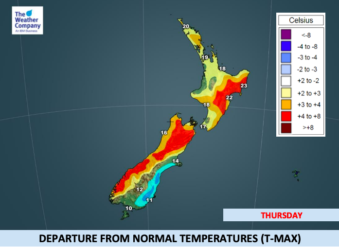
The cool down is big, shaving 10 to 15 degrees off daytime highs for some, however this big cool down will actually be resetting temperatures in many areas to levels more normal for October. Despite the big cool down on Thursday only the coastal Otago and Canterbury will be colder than average, everyone else remains average or even warmer than average.
On Wednesday afternoon maximum temperatures will be above average due to warmer winds ahead of the cold front. It will be 18-26C in most areas today and will be 5-8C higher than average, especially in the South Island and eastern North Island.
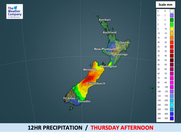
The front will bring needed rain to drier than normal Canterbury on Thursday and rain will fall across the South Island for a time, before clearing. Rainfall may reach 100-150mm until Thursday night over the western Southern Alps of the South island. There are risks of slips and even avalanche and localised flooding related to pockets of heavy rain and snow melting for a time.
It will turn colder in most areas of the South island by Thursday night after the front passes. Minimum temperatures will be below 0C or equal over mountains and will be around 5-8C in the plains of the South island. Rain will change to snow over high mountains (above 1000m) and snowfall of 10-15cm is expected in some areas.
About the North island, the front will give rain to Wellington on Thursday night along with a colder southerly. Although it reaches Auckland and Northland on Friday it will be much weaker by then and may only bring showers. It’s unlikely to bring much temperature drop to the upper North Island.


– WeatherWatch.co.nz
Comments
Before you add a new comment, take note this story was published on 23 Oct 2018.


Add new comment