Settled then some rain – NZ’s Weather Highlights for next 3 days
22/08/2016 7:00pm

> From the WeatherWatch archives
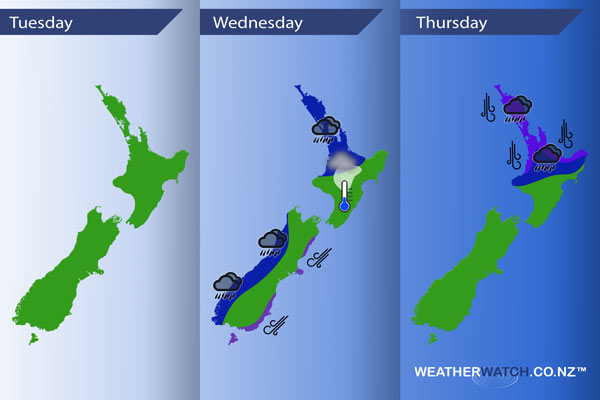
Today is mainly settled due to a ridge of high pressure then Wednesday and Thursday sees areas of rain, heavy falls possible mainly in the west and north.
Tuesday
Not to much going on, a cool start with even the chance of a light frost about inland areas for some but nothing serious. Mainly settled due to a ridge of high pressure.
Wednesday
White – A light frost to start the day for the inner North Island
A chance of fog about some inland North Island areas also.
Blue – Rain moves into the west of the country afternoon / evening, a chance some of this rain may be heavy mainly for the North Island’s West Coast.
Purple – Northeasterly winds becoming gusty / perhaps strong from afternoon along the South Island’s East Coast, easing overnight.
Thursday
Blue – Rain for the upper North Island, heavy at times then easing in the evening.
Purple – Northerly winds strong and gusty especially about coastal areas from afternoon then easing overnight as winds tend more northwest.

– Please note, the idea behind this update is to focus on the main weather highlights, which is why not all regions are mentioned.
For specific 10 day information for your city, town, rural community or island please see the 1000 forecasts on our homepage!
– Aaron Wilkinson, WeatherWatch.co.nz
Comments
Before you add a new comment, take note this story was published on 22 Aug 2016.


Add new comment