Pockets of severe weather as Mother’s Day low moves in (+5 Maps)
11/05/2019 8:06pm

> From the WeatherWatch archives
A burst of strong winds and rain is about to move across New Zealand with the warmer than average air flow switching to a colder southerly by Sunday night and Monday.
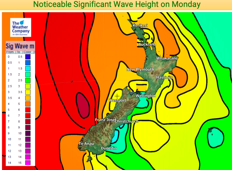
Generally speaking this isn’t a major system but it does have pockets of severe weather with gales, dangerous seas, some areas of heavy rain and then some snow on the mountains and ranges.
While Sunday morning looks fairly dry the afternoon and evening looks wetter as the low crosses NZ from west to east. The centre of the low will cross the lower South Island on Sunday evening with a colder southerly moving in behind it.
Not everyone is negatively impacted. Those in the east, like around Gisborne, may have a mainly dry and warm day with sunny areas.
Heaviest rain will be in the west of both islands, but especially the West Coast. Winds will be strongest in coastal wind tunnel areas, like Cook Strait and marine areas around Auckland. Damaging gusts are not currently forecast and winds in both Welington and Auckland cities look below gale force for the most part.
Snow is mostly around the Southern Alps and the cold change will impact the lower two thirds of the nation more than the upper North Island.
Warmer weather returns as early as Tuesday when winds switch from the cooler sou’west to milder westerly in many places.
Here are some of the main highlights for the next 48 hours…
FORECAST RAINFALL UP TO 6am MONDAY:
PEAK WINDS ON SUNDAY EVENING:
FORECAST SNOWFALL UNTIL 6am MONDAY:
WAVES:
SUNDAY AFTERNOON TEMPERATURES – DEPARTURE FROM NORMAL:
– WeatherWatch.co.nz
Comments
Before you add a new comment, take note this story was published on 11 May 2019.


Add new comment