> From the WeatherWatch archives
It’s a tiny storm but ex-cyclone Zaka is this evening passing to the east of East Cape and Gisborne creating dangerous seas says WeatherWatch.co.nz. The low, which WeatherWatch.co.nz maintained would be small and not directly hit New Zealand, weakened yesterday but has today surged a little more into life.
However it will pass the North Island in a considerably weaker state than yesterday and despite the centre being just 200kms away from land the system may not even bring cloud to the eastern tip of the North Island.
In fact the system is so small it may only bring a period of easterly winds for an hour or two this evening north of Gisborne and that’s all.
But the low could drive in some rough seas over the next 12 to 24 hours and WeatherWatch.co.nz says those around East Cape, Gisborne and Mahia Peninsula should be aware of the rough weather just 200kms out to sea.
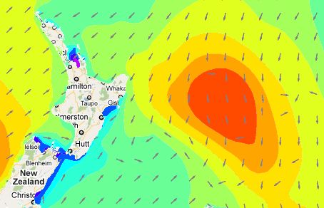
 This map, by Weathermap.co.nz, shows swell conditions at 7am on Wednesday morning. Swells near the centre of the low will be around 5 metres with a period of waves reaching 2 to 3 metres around East Cape and Gisborne for a while from tonight until Wednesday afternoon.
Swimmers in Hawkes Bay should also be aware of dangerous rips and large waves during Wednesday.
Conditions should ease by Thursday.
– WeatherWatch.co.nz
Comments
Before you add a new comment, take note this story was published on 8 Feb 2011.


Add new comment