> From the WeatherWatch archives
A northwesterly airflow builds over the country today with a front moving onto the lower South Island this evening, then moving northwards overnight. Thursday’s front moves over the North Island on Friday, then expect settled conditions on Friday with a ridge of high pressure.
Thursday
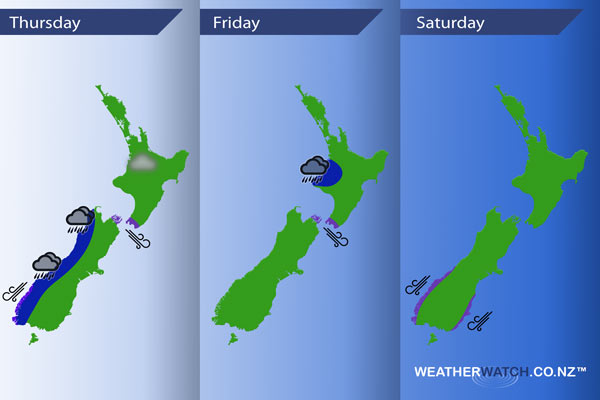
Blue – Heavy rain moves onto South Westland in the evening, then spreads northwards overnight.
Purple – Northwesterly winds become strong about the Cook Strait area from afternoon, with winds gusting to gale at times. Northeasterlies become strong about coastal Fiordland from afternoon, then ease in the evening.
A chance of fog first thing this morning for inland parts of the North Island.
Friday
Blue – A weakening front moves northwards over the North Island on Friday. This still may have enough energy to bring some heavy rain to Taranaki late afternoon / evening for a time.
Purple – Strong northwesterly winds through the Cook Strait area ease away in the afternoon.
Saturday
Purple – Saturday is mainly settled, however, overnight a northeasterly airflow increases over the South Island, especially in the south. This may bring gusty winds about coastal Fiordland and coastal Otago.

– Please note, the idea behind this update is to focus on the main weather highlights, which is why not all regions are mentioned.
For specific 10 day information for your city, town, rural community or island please see the 1000 forecasts on our homepage!
– Aaron Wilkinson, WeatherWatch.co.nz
Comments
Before you add a new comment, take note this story was published on 31 Aug 2016.


Add new comment