Your web browser (Internet Explorer) is out of date. Some things will not look right and things might not work properly. Please download an up-to-date and free browser from here.
4:43am, 26th December
Home > News > Next 10 days – Rain stays mostly w...
Next 10 days – Rain stays mostly west, but heads south
25/08/2016 10:00pm

> From the WeatherWatch archives
For 36 hours straight parts of northern New Zealand have had plenty of rain – but as we look towards the next 10 days the rain makers are shifting further south in what looks to be a more “normal” set up.
As we reported yesterday “West Coast rain” came to Auckland – that set in wet weather for over a day is unusual for northerners but the upper North Island had the right conditions for this to occur over Wednesday and Thursday this week.
As we head into next week fronts will be coming at New Zealand from the Southern Ocean for the most part, putting the West Coast smack bang in the firing line.
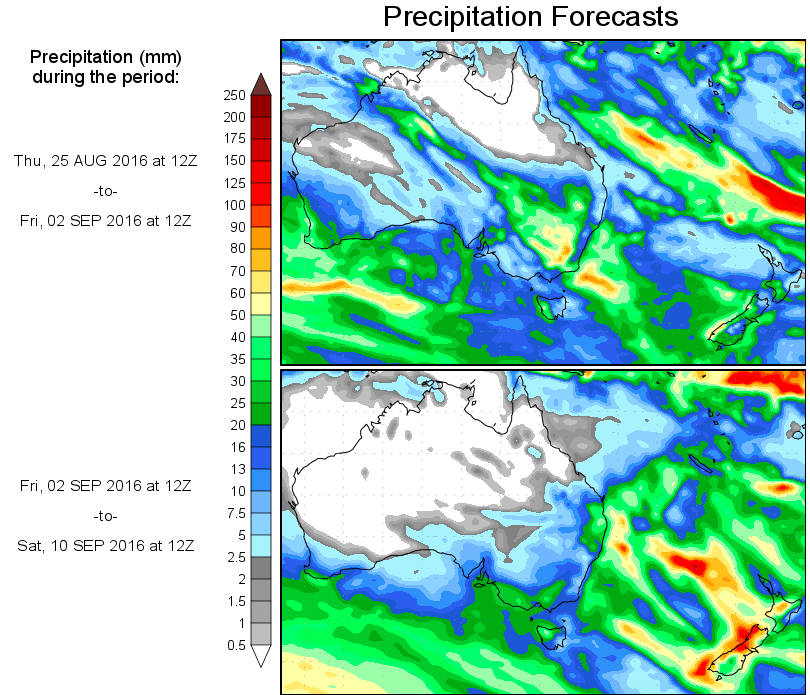
Total rainfall amounts over the coming week and half may climb to 150mm or above for the West Coast.
If you’re in Canterbury and desperate for rain we have both good and not so good news.
The good is that patchy rain is this morning spreading into North Canterbury. The not so good news is that it’s not overly widespread – and that the next week ahead looks mainly dry. However, there may be some spillover from the heaviest West Coast rain events for Canterbury farms that are closer to the foothills/main divide.

Close up:
– Maps / GFS
– WeatherWatch.co.nz
Comments
Before you add a new comment, take note this story was published on 25 Aug 2016.
Latest Video
Low pressure moving in for end of 2025
Low pressure looks to be driving New Zealand’s weather more as we enter the final 7 days of 2025. For…
Related Articles
Low pressure moving in for end of 2025
Low pressure looks to be driving New Zealand’s weather more as we enter the final 7 days of 2025. For…
Santa Tracker 2025!
We’ve switched off the live Santa Tracker, displaying the final image at 11pm Christmas Eve. Comments posted after 11pm Christmas…
Weather for Christmas & NYE: The good, the bad and the ugly…
Low pressure, windy weather, hot and cold – it’s all in the mix over the coming days, bringing both hot…
Navigation
© 2025 WeatherWatch Services Ltd


Add new comment