> From the WeatherWatch archives
GNS Science takes a flight of Mt Tongariro (Photos included below) and note that blocks were thrown more than 1.5kms from a new vent area below the Upper Te Maari crater. Current eruptive activity is low level but could re-commence at any time. The Volcanic Alert Level stays at Level 2. The Aviation Colour Code is reduced to Yellow, which recognises that activity has decreased but renewed unrest is possible. Full details below (from GNS Science)
From 4pm Wednesday — A brief period of good weather this morning allowed GNS Science and Department of Conservation scientists to make an observation flight to Mt Tongariro. Seismic activity remains at a low level with only a few small events being recorded today. These observations and current monitoring data do not change the prognosis for future eruptions.
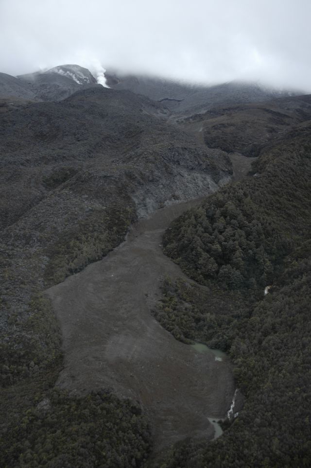
Actively steaming vents (photo below) were visible at a new crater area below Upper Te Maari crater but low cloud prevented any views above this elevation.

No vents have opened in or around the Lower Te Maari crater, or at lower elevations on the mountain. There are no new vents or craters at the Ketetahi thermal area. Previously steaming ground at Ketetahi and Lower Te Maari crater appears more vigorous, but there were no obvious major changes there.
Blocks of old lava and hydrothermally altered lava up to approximately 1 metre size have been ejected by the eruption. There are extensive areas to the east and west of the new vents where falling blocks have formed impact craters in the ground. No burnt vegetation was seen. No steaming hot blocks were visible and all appeared to be angular shapes more typical of existing old rock, rather than fresh lava or scoria. Most blocks were covered by grey ash but many on the western slopes were not, which suggests that they were ejected after the main ash-producing phase of the eruption had finished. Blocks had reached 1.5 km to 2 km from the Te Maari craters area.
 A flow of rock and soil debris generated by the eruption partly fills a stream valley draining northwest from Upper Te Maari crater area (see photo below). The deposit has blocked some stream tributaries but most water appears to be diverted around the edges. Ash has slumped from the banks into this stream valley and in other stream valleys ash has been re-mobilised in slurry flows. No lahars were generated by the eruption.
New rock falls were visible around the walls of the new vent area and Lower Te Maari craters and in some stream valley walls near the craters. This is a sign that significant ground shaking took place during Monday night’s eruption.
Images taken by GNS Science from this morning’s flight will be available to the public through the GeoNet website at http://www.geonet.org.nz/
The Volcanic Alert Level stays at Level 2. The Aviation Colour Code is reduced to Yellow.
– GNS Science
Comments
Before you add a new comment, take note this story was published on 8 Aug 2012.


Add new comment