> From the WeatherWatch archives
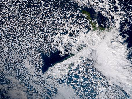
One thing about cold southerlies, they usually bring a lot of dry air with them which means snow events can turn to just the odd snow shower with long sunny spells. However over the next 24 hours a developing low pressure system around the eastern North Island will deepen and then inject moisture into this cold southerly. The result? Heavy snow in the mountains and heavy rain for some in the east lower down.
To track this rain, use our Forecast Rain Radar to get a clearer picture of where the bulk of this wet weather is – but basically it’s coming in from the east and will impact areas mainly between North Canterbury (mountains) and Wairarapa/Hawke’s Bay.
There is some chance of localised flooding in these eastern areas from slow moving prolonged rain (like Wairarapa).
With the cold southerly injection this heavy rain will fall as heavy snow – and could impact State Highways in the North Island over the next couple of days, especially in Central Plateau.
It eases later on Friday as it tracks into Hawke’s Bay and falls apart on Saturday in coastal Hawke’s Bay and Gisborne as a large high pushes most of this weather out east of New Zealand.

– Image / Cloud draped over the country as of 10am, the West Coast has clearer skies thanks to the southerly flow and the mountains blocking the cloud / JMA
– WeatherWatch.co.nz
Comments
Before you add a new comment, take note this story was published on 11 Jul 2017.


Add new comment