> From the WeatherWatch archives
High pressure is dominating New Zealand for the first half of this week, but by Thursday and Friday a deepening sub-tropical low will cross over the North Island.
It is not currently a storm and most computer modelling shows it deepening but not becoming overly aggressive – but it is sizeable, meaning this low will bring in some wind and rain, mostly Thursday to Saturday.
With the low not especially deep most of the windy weather will actually form in the ‘squash zone’ between this low and the high currently over New Zealand.
Large lows can sometimes be quite slow moving with plenty of dry areas and even calm areas – it’s not days of nonstop wind and rain for most.
Thursday sees the rain band sliding southwards with windy easterlies in that ‘squash zone’ over the North Island and central parts of New Zealand.
As this rain heads south it will meet colder air over the South Island – creating for heavy snow falls in the mountains and ski fields. Further south into Otago, Southland and South Westland and much of the rain from this low should miss you.
Friday looks snowy over the eastern Southern Alps towards Canterbury while the centre of the low comes into the upper North Island. Timing is everything – but if the current modelling is accurate than we may see a calmer, showery, change in the north on Friday.
By Saturday New Zealand is colder and showery under a large sou’west flow – with showers and winds likely easing into Sunday.

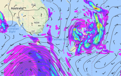
– Image / Noon Friday shows the large low over the country with areas of rain, showers and dry spells – also a mix of windy weather and calm spells too. A messy forecast that will be fine tuned further over the coming day or two.
– WeatherWatch.co.nz
Comments
Before you add a new comment, take note this story was published on 20 Jun 2017.


Add new comment