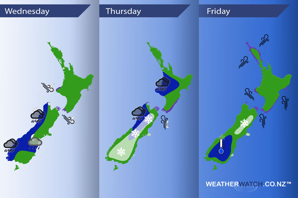
InfoGraphic: The Main Weather News Highlights across NZ: Wed, Thu, Fri
25/07/2017 7:00pm

> From the WeatherWatch archives
A west to northwesterly airflow builds over New Zealand today then a front moves onto the lower South Island in the afternoon before gradually pushing northwards through the evening and overnight. Winds change southerly behind the front. Southerlies over the South Island spread onto the lower North Island in the evening, south to southwest winds cover the country on Friday.
Wednesday
Blue – Heavy rain spreads northwards along the West Coast during the day, reaching Buller overnight. About North Otago / South Canterbury some heavy rain may develop overnight.
Purple – Northwesterlies build in the evening / overnight through the Cook Strait area becoming gusty.
Thursday
Blue – Heavy rain eases from afternoon about North Westland. Rain becoming heavy in the morning about Taranaki, easing from afternoon. Rain with possible heavy falls about the Waikato / Central North Island in the afternoon then easing in the evening.
White – Snow flurries about Southland / Otago to 400m lowering to low levels (200 to 100m) by evening. Canterbury sees snow to 700m lowering to 200m overnight.
Purple – Southerlies becoming brisk to strong about the Marlborough Sounds / lower North Island in the evening.
Friday
A frosty start about the lower South Island, heavy frosts possible. A few low level snow flurries about the east of the South Island ease and clear overnight, snow is not heavy. Brisk to strong southerly quarter winds for the North Island ease overnight although remaining brisk in the east.

– Please note, the idea behind this update is to focus on the main weather highlights, which is why not all regions are mentioned.
For specific 10 day information for your city, town, rural community or island please see the 1500 forecasts on our homepage!
– Aaron Wilkinson, WeatherWatch.co.nz
Comments
Before you add a new comment, take note this story was published on 25 Jul 2017.


Add new comment