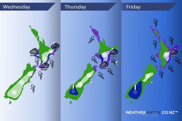
InfoGraphic: The Main Weather News Highlights across NZ: Wed, Thu, Fri
11/07/2017 7:00pm

> From the WeatherWatch archives
Today sees a very cold southerly airflow cover New Zealand with a low deepening later in the day east of the North Island. A squash zone develops between the low about the eastern North Island and an incoming ridge in the far south on Thursday creating very strong winds about central New Zealand and some heavy rain. Friday sees a ridge slowly make some headway over the South Island while strong south to southeasterly winds ease later in the day over the North Island.
Wednesday
Blue – Rain heavy for a time about Taranaki in the afternoon, about Hawkes Bay / Gisborne in the evening and overnight. Rain about Wairarapa, Wellington and perhaps Manawatu becoming heavy overnight.
White – Bitterly cold south to southwesterly winds bring snow flurries to low levels (200 to 100m) at times for much of the southern and eastern South Island. Flurries may reach to near sea level at times.
Snow flurries about the Central North Island to 700m at first then lowering to 400m or perhaps even 300m in the afternoon, clearing in the evening. Flurries about the Wellington region to 300m clear around midday. Some snow lowers to 300m for a time about the Wairarapa, 500 or perhaps 400m about Hawkes Bay then 600m in the evening for Gisborne about the ranges. Overnight as heavy rain pushes into the Wairarapa with it comes heavy snow to 500m, 400m for Wellington.
Purple – Southerly winds strengthen during the day through central and eastern New Zealand, gusting to gale at times about coastal areas especially afternoon onwards. Severe gales may develop through Cook Strait overnight.
Thursday
Blue – Heavy rain affects lower parts of the North Island on Thursday (flooding looking likely about the Wairarapa), heavy rain not reaching Hawkes Bay / Gisborne till overnight.
A tad frosty about Central Otago around dawn where skies are clear, especially in the west.
White – Snow flurries to 300m about Canterbury, there may be isolated lines / areas feeding in that bring some persistent snow while other spots may see very little. Otago may see a few flurries to 300m during the day also however amounts will be fairly insignificant.
The Wellington region sees heavy snow to 400m, easing from afternoon.
Heavy snow for Wairarapa down to 600 or 500m, there is quite a sharp temperature gradiant so one end of Wairarapa may have a higher snow level then further south. Snow generally sticking above 600 to 700m for Hawkes Bay / Gisborne and the Central North Island.
Purple – Winds very strong from the south or southeast with severe gales likely especially through the Cook Strait area. Southwesterlies becoming strong to gale about Auckland / Northland then easing in the evening.
Friday
Blue – Heavy rain about Hawkes Bay / Gisborne eases afternoon / evening.
Heavy frosts about the lower South Island in the morning.
White – a few remaining snow flurries down to 400 or perhaps 300m about Canterbury gradually easing during the day and mostly clearing by evening. Accumulations will be fairly limited on Friday, snow is not heavy.
Snow sticking above 600 to 700m about Hawkes Bay / Gisborne. Snow to 500m about the Central North Island in the morning then easing / clearing away.
Purple – South to southeasterly winds will be strong over much of the North Island, easing in the evening. Winds strongest along the east coast with gales likely.

– Please note, the idea behind this update is to focus on the main weather highlights, which is why not all regions are mentioned.
For specific 10 day information for your city, town, rural community or island please see the 1500 forecasts on our homepage!
– Aaron Wilkinson, WeatherWatch.co.nz
Comments
Before you add a new comment, take note this story was published on 11 Jul 2017.


Add new comment