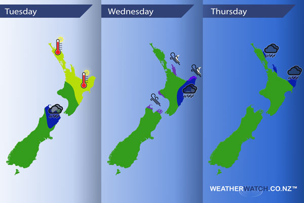
InfoGraphic: The main Weather News Highlights across NZ: Tue, Wed, Thu
6/02/2017 6:00pm

> From the WeatherWatch archives
A front moves over the upper South Island today, onto the lower North Island during the afternoon / evening. The airflow is generally from the northwest ahead of the front and from the south in behind. Frontal activity continues to affect the North Island on Wednesday while cool southerlies lie over the South Island, this front slowly moves away from the North Island on Thursday while a northeasterly airflow develops in the south.
Tuesday
Yellow – Temperatures reaching into the early 30’s for the east of the North Island and about Northland. Mid to late 20’s elsewhere.
Wednesday
Blue – Rain about the eastern North Island may be persistent, it may not be all that heavy however since no rain has fallen about the east of the North Island for a while this is definitely welcome news.
Purple – Southeasterlies becoming brisk to strong for the areas marked in purple below. Gusty / strong about the Coromandel and western parts of East Cape from evening.
Thursday
Blue – Rain which may be heavy about exposed northeastern parts of the North Island, eases away from afternoon.

– Please note, the idea behind this update is to focus on the main weather highlights, which is why not all regions are mentioned.
For specific 10 day information for your city, town, rural community or island please see the 1500 forecasts on our homepage!
– Aaron Wilkinson, WeatherWatch.co.nz
Comments
Before you add a new comment, take note this story was published on 6 Feb 2017.


Add new comment