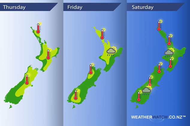
InfoGraphic: The Main Weather News Highlights across NZ: Thu, Fri, Sat
20/12/2017 6:37pm

> From the WeatherWatch archives
A front lines up and moves over the South Island today while it’s mainly settled further north. Mainly settled for most on Friday as high pressure muscles it’s way in from the Tasman. High pressure for most of the country on Saturday.
Thursday
Yellow – Temperatures reaching into the mid to late twenties for the eastern South Island northwards. Perhaps early thirties for the eastern South Island for a time this afternoon.
Some rain pushes into South Westland during this morning, it may be briefly heavy for a time.
Friday
Yellow – Warm afternoon temperatures for the lower South Island, also about inland Buller. The western / upper North Island sees the hottest temperatures reaching into the late twenties.
A few isolated heavy showers may develop late afternoon / evening about inland Bay Of Plenty.
Saturday
Afternoon high’s reaching into the mid twenties for the inner South Island on Saturday, also some parts of the North Island mainly in the west. Watch for an isolated downpour late afternoon or evening about inland Taranaki / western Waikato, perhaps also about inland eastern Otago / inland South Canterbury about the ranges although the heavy shower risk for the South Island is on the lower side.

– Please note, the idea behind this update is to focus on the main weather highlights, which is why not all regions are mentioned.
For specific 10 day information for your city, town, rural community or island please see the 1500 forecasts on our homepage!
– Aaron Wilkinson, WeatherWatch.co.nz
Comments
Before you add a new comment, take note this story was published on 20 Dec 2017.


Add new comment