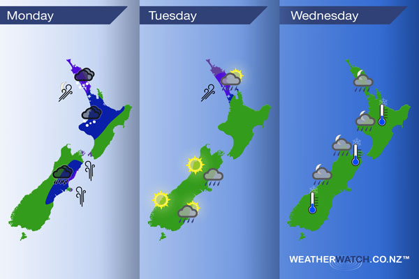
InfoGraphic: The Main Weather News Highlights across NZ: Mon, Tue, Wed
18/09/2017 12:16am

> From the WeatherWatch archives
A large low brings unsettled weather to most of the country today, centred just east of central New Zealand. A gusty south to southwesterly airflow eases later on Tuesday as a ridge of high pressure starts to move in however it doesn’t last long as another front starts to move towards the west from the Tasman Sea.
Monday
Blue – Rain about the eastern South Island may be heavy at times today, especially late afternoon / evening then starting to ease overnight.
Showers for the upper / western North Island will be heavy at times today with a risk of hail, perhaps some lightning and thunder at times also.
Purple – Southerly winds becoming gusty about the North Canterbury coast late afternoon then easing a little overnight. Westerlies will be fairly blustery about the western North Island for much of today however overnight a period of strong southwesterlies moves through Northland and northern parts of Auckland, winds may gust to gale in coastal areas.
Tuesday
Blue – Early heavy showers ease for Northland / Auckland.
Purple – Gusty southwesterlies quickly ease about Northland and Auckland during the morning.
Showers for the eastern South Island ease during the day, mostly clearing by evening. A great day for the West Coast with sunny conditions all day long.
Wednesday
Potential for a light frost to start the day about some inland areas in the morning. Overnight as a front moves in from the west there could be a few heavy showers for western areas.

– Please note, the idea behind this update is to focus on the main weather highlights, which is why not all regions are mentioned.
For specific 10 day information for your city, town, rural community or island please see the 1500 forecasts on our homepage!
– Aaron Wilkinson, WeatherWatch.co.nz
Comments
Before you add a new comment, take note this story was published on 18 Sep 2017.


Add new comment