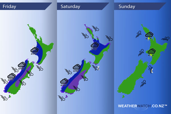
InfoGraphic: The main Weather News Highlights across NZ: Fri, Sat, Sun
7/09/2017 7:00pm

> From the WeatherWatch archives
Today sees a front move in from the Tasman Sea, hitting the South Island from afternoon then the North Island overnight. This front gradually moves off the North Island on Saturday to the northeast meanwhile a deep low passes by the south of the South Island. A cold and potentially unstable southwesterly airflow for Sunday.
Friday
Blue – A front moving onto the South Island this afternoon from the west brings heavy rain to the West Coast, spreading northwards then moving onto the western North Island overnight. Chance of a rumble of thunder at times within this heavy rain.
Purple – Northwesterlies are looking to be brisk / strong for many parts of New Zealand ahead of this front, winds are strongest about the inner South Island in the afternoon and elsewhere late afternoon / evening.
Saturday
Blue – Heavy rain eases around midday for the Western North Island to showers, showers may however be heavy at times with a risk of thunder. Rain, heavy at times along the West Coast of the South Island, especially afternoon onwards with a risk of thunder.
Purple – A deep low moving past the lower South Island brings strong northwesterly winds for much of the day about many parts of the South Island, winds may gust to gale at times. Winds pick up from the northwest later in the evening / overnight through Cook Strait with a risk of hales.
Northwesterlies about the upper South Island are gusty / strong about coastal areas then easing from afternoon.
Sunday
Heavy showers for the western North Island on Sunday, thunderstorms and a risk of hail too. Brisk to strong southwesterlies for western parts of the North Island during the day. Brisk / strong southwesterlies develop in the morning about coastal Canterbury, reaching Wellington in the form of a Southerly later in the evening.

– Please note, the idea behind this update is to focus on the main weather highlights, which is why not all regions are mentioned.
For specific 10 day information for your city, town, rural community or island please see the 1500 forecasts on our homepage!
– Aaron Wilkinson, WeatherWatch.co.nz
Comments
Before you add a new comment, take note this story was published on 7 Sep 2017.


Add new comment