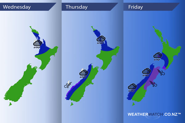
InfoGraphic: The main Weather Highlights across NZ for next 3 days
13/09/2016 7:00pm

> From the WeatherWatch archives
An anticyclone covers most of New Zealand today while a front snakes its way onto the west of the North Island, intensifying overnight. This front moves away on Thursday while a north to northwesterly airflow then builds over the rest of New Zealand. Friday sees a front move northwards over the country during the day in a strong northwesterly airflow.
Wednesday
Blue – Some rain moves onto the west of the North Island this afternoon, just north of Taranaki but staying south of Auckland. There is a chance this rain may be heavy, however, a greater chance of heavy rain comes overnight (towards dawn on Thursday) and covers a slightly larger area.
Thursday
Blue – Rain for the upper North Island may be heavy in the morning then easing by midday. Rain moves onto the West Coast of the South Island overnight with heavy falls.
Purple – Northeasterly winds strengthen about coastal Fiordland overnight.
Friday
Blue – Heavy rain for the West Coast of the South Island during the day, more so in the morning. Areas of heavy rain move onto the lower North Island in the west during the afternoon.
Purple – A strong northerly airflow covers much of the South Island and lower North Island in the morning but this flow becomes more intense during the afternoon as winds tend strong northwest. Winds may gust to gale from the northwest from midday onwards about the likes of Canterbury and Marlborough, especially inland, and also the Cook Strait area.

– Please note, the idea behind this update is to focus on the main weather highlights, which is why not all regions are mentioned.
For specific 10 day information for your city, town, rural community or island please see the 1000 forecasts on our homepage!
– Aaron Wilkinson, WeatherWatch.co.nz
Comments
Before you add a new comment, take note this story was published on 13 Sep 2016.


Add new comment