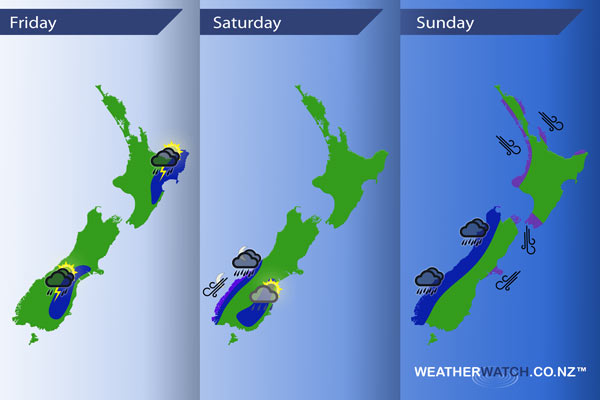
InfoGraphic: The main Weather Highlights across NZ for next 3 days
3/11/2016 6:00pm

> From the WeatherWatch archives
A southwesterly airflow lies over the country today with conditions becoming unstable in the east for some, then on Saturday a westerly airflow lies over the North Island while a northwesterly airflow develops over the South Island. A front pushes northwards over New Zealand on Sunday, gusty northerlies ahead of the front then tending more northwest in behind.
Friday
Blue – Showers about the eastern South Island may become heavy with thunderstorms and hail in the afternoon then easing later in the evening.
From afternoon showers develop about the east of the North Island, a chance these may turn heavy with thunderstorms then clearing in the evening.
Saturday
Blue – Isolated showers possible about eastern Southland / Otago late afternoon and evening, a low risk one or two of these may be heavy.
Overnight heavy rain moves into South Westland.
Purple – Strong northeasterlies develop about coastal Fiordland ovenight.
Sunday
Blue – Heavy rain for the West Coast of the South Island eases from afternoon, while this front does move onto the western North Island in the afternoon the front looks to have weakened a little by then meaning the heavy rain risk is not as great.
Purple – Gusty northeasterly winds about coastal Canterbury ease from afternoon as winds tend northwest.
Strong northerlies through Cook Strait with winds rising to gale at times ease later in the evening or overnight.
Gusty / strong northwesterly winds about coastal fringes of the upper North Island from afternoon then easing later in the evening.

– Please note, the idea behind this update is to focus on the main weather highlights, which is why not all regions are mentioned.
For specific 10 day information for your city, town, rural community or island please see the 1500 forecasts on our homepage!
– Aaron Wilkinson, WeatherWatch.co.nz
Comments
Before you add a new comment, take note this story was published on 3 Nov 2016.


Add new comment