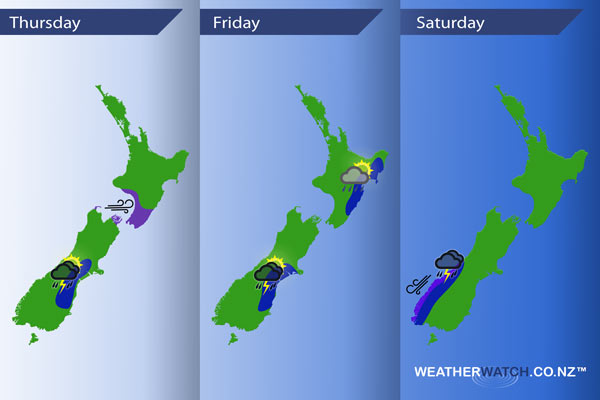
InfoGraphic: The main Weather Highlights across NZ for next 3 days
2/11/2016 6:00pm

> From the WeatherWatch archives
A front pushes up the western side of New Zealand today, reaching the North Island this afternoon meanwhile a low sits to the east of the South Island directing in a southerly change. A southwesterly airflow lies over the country on Friday then on Saturday a westerly airflow lies over the North Island while a northwesterly airflow builds over the South Island.
Thursday
Blue – From early afternoon a south to southwest change triggers heavy showers and a risk of hail for the eastern South Island, a chance of thunderstorms also.
Purple – Brisk to strong westerly winds afternoon and evening about parts of the lower North Island, also the Marlborough Sounds and about Farewell Spit.
Friday
Blue – Showers about the eastern South Island may become heavy with thunderstorms and hail in the afternoon then easing later in the evening.
From afternoon showers develop about the east of the North Island, a chance these may turn heavy with thunderstorms then clearing in the evening.
Saturday
Blue – Overnight heavy rain and possible thunderstorms move into South Westland.
Purple – Strong northeasterlies develop about coastal Fiordland ovenight.

– Please note, the idea behind this update is to focus on the main weather highlights, which is why not all regions are mentioned.
For specific 10 day information for your city, town, rural community or island please see the 1500 forecasts on our homepage!
– Aaron Wilkinson, WeatherWatch.co.nz
Comments
Before you add a new comment, take note this story was published on 2 Nov 2016.


Add new comment