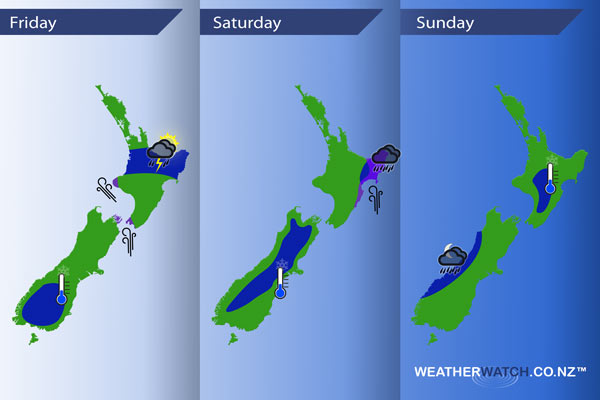
InfoGraphic: The main Weather Highlights across NZ for next 3 days
20/10/2016 6:00pm

> From the WeatherWatch archives
Potentially unstable weather may move onto parts of the North Island today while conditions ease over the South Island due to a ridge of high pressure. Mainly settled on Saturday however southerlies about the eastern North Island still bring showers or rain, possibly heavy. Settled for most on Sunday, a front approaches in the Tasman Sea.
Friday
Blue – Late afternoon / evening showers about the North Island as depicted below may turn into thunderstorms with hail and isolated heavy falls. Then clearing overnight.
A frosty start about the lower South Island, just a light frost.
Purple – Strong south to southeasterly winds blow through Cook Strait and affect parts of Taranaki from midday.
Saturday
Blue – Rain about Hawkes Bay (mainly in the north) and Gisborne heavy at times during the day then easing in the evening.
A light frost is possible for parts of the inner South Island to start the day.
Purple – Brisk to strong southerlies about the Eastern North Island ease later in the evening.
Sunday
Blue – Some rain for the West Coast of the South Island overnight may be heavy due to a front pushing in from the Tasman Sea.
A light frost to start the day for some inner parts of the North Island.

– Please note, the idea behind this update is to focus on the main weather highlights, which is why not all regions are mentioned.
For specific 10 day information for your city, town, rural community or island please see the 1500 forecasts on our homepage!
– Aaron Wilkinson, WeatherWatch.co.nz
Comments
Before you add a new comment, take note this story was published on 20 Oct 2016.


Add new comment