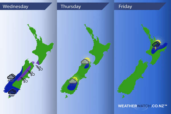
InfoGraphic: The main Weather Highlights across NZ for next 3 days
18/10/2016 6:00pm

> From the WeatherWatch archives
Wednesday sees a northwesterly airflow continue however it does weaken, a weakening front lies over the lower North Island while another front moves onto the lower South Island from afternoon. A series of fronts lie over the country on Thursday with ppotentially unstable weather for some parts of the South Island, this unstable weather may move onto the North Island on Friday.
Wednesday
Blue – Rain about Fiordland becomes heavy from afternoon, pushing northwards overnight.
Purple – Expect brisk to strong northwesterly winds about the east of the South Island (mainly inland), easing in the morning. Winds strong through Cook Strait for much of the day.
Thursday
Blue – Cold upper air brings the chance of heavy afternoon / evening showers about the lower and upper South Island. There is a chance these showers could turn into thunderstorms with hail but at this stage thunderstorms are a low risk.
Friday
Blue – Afternoon and evening showers about the North Island as depicted below may turn into thunderstorms with hail and isolated heavy falls. Then clearing overnight.

– Please note, the idea behind this update is to focus on the main weather highlights, which is why not all regions are mentioned.
For specific 10 day information for your city, town, rural community or island please see the 1500 forecasts on our homepage!
– Aaron Wilkinson, WeatherWatch.co.nz
Comments
Before you add a new comment, take note this story was published on 18 Oct 2016.


Add new comment