InfoGraphic: The main Weather Highlights across NZ for next 3 days
10/10/2016 6:00pm

> From the WeatherWatch archives
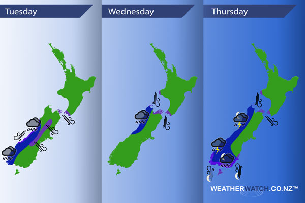
Fairly tame across the North Island today, a front sits over the lower South Island from early morning then slowly pushes northwards during the day. Wednesday sees a yesterdays front move over the upper South Island in the morning then onto the North Island in the afternoon, winds change west to southwest in behind. A northwesterly airflow lies over New Zealand on Thursday with a front pushing onto the West Coast overnight.
Tuesday
Blue – Some heavy rain affects South Westland during the day, slowly moving into North Westland overnight.
Purple – Northwesterly winds from afternoon become strong about the Cook Strait area. About the interior of the South Island northwesterly winds are likely to be strong from afternoon.
Wednesday
Blue – Areas of heavy rain about North Westland and Buller ease from afternoon.
Purple – Northerly winds about the top of the South Island and through Cook Strait are brisk to strong, easing in the evening.
Thursday
Blue – Areas of rain about Fiordland with the odd heavy fall, pushing northwards overnight. Chance of a thunderstorm or two.
Overnight rain about Southland and Otago may be heavy.
Purple – From evening north to northwesterly winds about the top of the South Island and through Cook Strait become gusty / strong.
Gusty southerly winds develop about the lower South Island overnight, mainly near the coast.
– Please note, the idea behind this update is to focus on the main weather highlights, which is why not all regions are mentioned.
For specific 10 day information for your city, town, rural community or island please see the 1500 forecasts on our homepage!
– Aaron Wilkinson, WeatherWatch.co.nz
Comments
Before you add a new comment, take note this story was published on 10 Oct 2016.


Add new comment