Darwin: Severe Tropical Cyclone Fina tracks right past city
21/11/2025 10:52pm
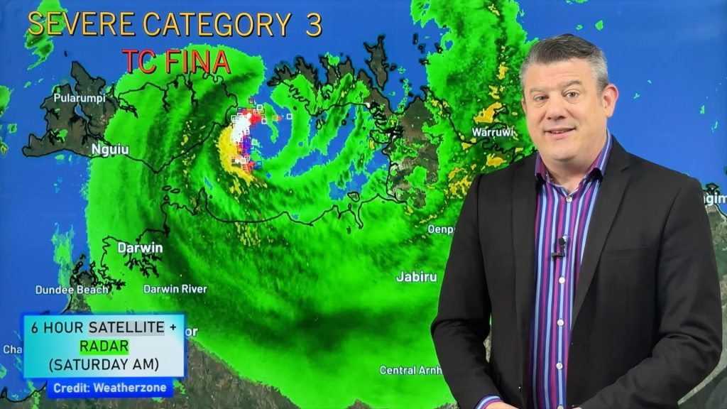
Saturday AM update — It’s a more serious forecast for Darwin Saturday with Cyclone Fina upgraded to a Severe Category 3 Tropical Cycloneby Australia’s Bureau of Meteorology. It lies over very warm seas that will continue to fuel it and potentially power it up even further.
In today’s special video we cover the latest tracking, which shows the severe cyclone passing near Darwin.
Rain and wind will build in Darwin and surrounding towns and communities in the north-west of the Top End.
We expect the worst of the winds to peak Saturday night, then easing back on Sunday AM in Darwin, likely before sunrise.
Heavy rain and thunderstorms, possibly severe, are also in the mix and could boost rainfall to over 300mm in just 24 hours in some locations.
We will have extra updates posts on our social media account: https://x.com/WeatherWatchNZ
Those in the Top End and the Kimberley should keep up to date with all official warnings from local NT & WA authorities and the Bureau of Meteorology.
Comments
Latest Video

Unsettled Thu/Fri, high pressure returns this weekend & next week
Wind and some wet weather is moving into both ends of NZ today and tomorrow bringing broken up rain bands…
Related Articles
Unsettled Thu/Fri, high pressure returns this weekend & next week
Wind and some wet weather is moving into both ends of NZ today and tomorrow bringing broken up rain bands…
Subtropical low, windy for some, then high pressure slowly returns
It’s cloudy and windy for parts of New Zealand today with the North Island especially gloomy under cloud associated with…
Subtropical low next week worth monitoring as high pressure controls all
High pressure smothers NZ today and will weaken a little on Sunday and Monday to allow a cooler southerly flow…


Add new comment