> From the WeatherWatch archives
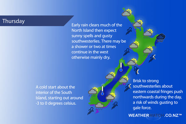
A cold southwesterly airflow for New Zealand on Thursday, a front bringing a few showers and strong winds to eastern coastal areas moves onto the lower South Island during the morning then moving northwards reaching the eastern North Island later in the evening / overnight.
Early rain about the upper North Island then easing to sunny spells and the odd shower, gusty southwesterlies develop early on especially about Auckland.
For the lower North Island in the west expect morning showers, possibly heavy then clearing by midday with sunny spells increasing. Southwesterly winds, gusty about Taranaki. Morning rain, possibly heavy about Gisborne then clearing away in the afternoon with sunny spells increasing. Breezy cool southwesterly winds becoming gusty overnight about coastal fringes.
Early morning showers clear about Wellington then sunny spells increase, fresh southerlies die out late afternoon. A few further showers late evening or overnight as southerly winds pick up again becoming strong.
Any early showers clear for Nelson and Marlborough then becoming sunny with southwesterly winds, perhaps dying out about Marlborough for a time. Southwesterlies freshen in the evening for Marlborough with some cloud possible.
Sunny or becoming sunny early on for Canterbury, some cloud and a few showers possible late afternoon / evening evening as southwesterly winds freshen. Southwest winds may be fairly brisk, strong about the coast where winds may even gust to gale. Overnight skies clearing up although a shower or two may remain about outer parts of Banks Peninsula. A frosty start then cold again overnight.
Becoming mostly sunny early morning along the West Coast, winds fairly cool from the southwest. Some cloud and a few showers (mainly coastal) late afternoon / evening then clearing away at night. Dry at first with some sun and westerlies about Southland and Otago, a fresh southwest change (strong to gale about coastal areas) developing during the morning brings a few showers which clear in the afternoon. Showers may not clear coastal Otago till overnight.
Blue – Heavy form of precipitation.
Purple – Strong winds.
Yellow – Temperatures around the mid 20 degree mark or over.

Not all regions and towns have been mentioned above. For specific 10 day information for your city, town, rural community or island please see the 1500 forecasts on our homepage!
– Aaron Wilkinson, WeatherWatch.co.nz
Comments
Before you add a new comment, take note this story was published on 3 May 2017.


Add new comment