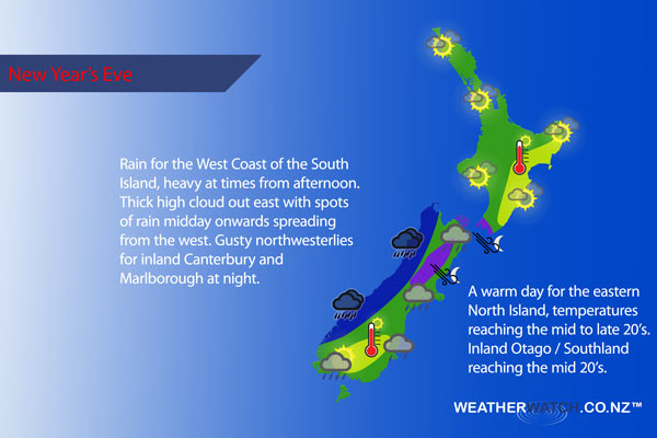
InfoGraphic: The Big Picture for New Year’s Eve
30/12/2016 5:02am

> From the WeatherWatch archives
Basically the North Island is looking to have the best weather tomorrow, a north to northwesterly airflow over the South Island is keeping conditions mainly cloudy with rain in the west spreading eastwards at times. A ridge over the far north is holding this weather back for most of the North Island.
For the upper North Island expect mostly sunny weather, some high cloud increases from afternoon but most importantly it’s looking mainly dry. There is the lowest of low risks that an isolated shower may pop up late afternoon for some inland areas but this shouldn’t be an issue. Winds are generally light from the north tending a little more onshore during the afternoon.
The lower North Island sees high cloud increasing from morning, winds from the north or northwest. Cloud thickening and lowering in the west from evening although it stays mainly dry apart from Wanganui southwards which may see a shower or two from late evening. Northwesterlies strengthen during the day through Cook Strait, perhaps reaching gale at times overnight.
The east coast of the North Island is mainly sunny, high cloud increasing from afternoon mostly. Northeasterly breezes. Temperatures in the east getting into the mid 20’s during the afternoon.
The West Coast of the South Island sees rain, heavy at times from afternoon. The east coast, plenty of thick high cloud with rain spreading at times from the west afternoon onwards. Northwesterlies inland becoming gusty / strong overnight.
A few morning showers clear parts of Southland and perhaps inland Otago then sun breaking through in the afternoon, cloud thickens up again later in the day with rain again for a time overnight.

Not all regions and towns have been mentioned above. For specific 10 day information for your city, town, rural community or island please see the 1500 forecasts on our homepage!
– Aaron Wilkinson, WeatherWatch.co.nz
Comments
Before you add a new comment, take note this story was published on 30 Dec 2016.


Add new comment