Hot & dry for many + Tropical Cyclone potential next week near Solomons/Vanuatu
4/12/2025 10:23pm
The first tropical cyclone of the South Pacific Cyclone season may be forming next week well north of NZ with the Solomon Islands, Vanuatu and New Caledonia most exposed. Any potential tracking into the New Zealand area will heavily depend on high pressure which is expected to be moving in to our nation a week from now. For now this is just one to monitor but poses no immediate threat to New Zealand – but it’s positioning on the planet means it may track towards us at some point.
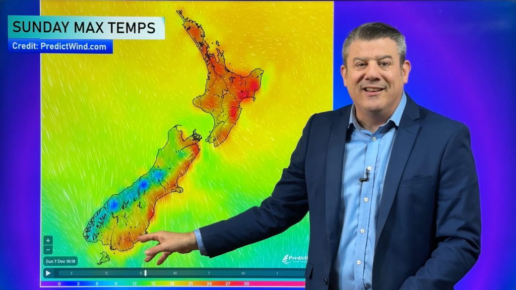
In the meantime NZ is about to heat up and dry out – with Australian and sub-tropical nor’westers kicking in those in the east, the north and inland areas of both main islands will be in the upper 20s and lower 30s temperature-wise between now and mid-next week. There will also be some brief cooler changes in the mix as airflows shift around a little for some regions.
Rainfall is low over the coming week – except for the southern half of the western South Island.
We have your 7 day forecast for NZ and rainfall map too.
Have a great weekend!
Comments
Latest Video
Rare blood moon lunar eclipse tonight + Yes, NZ’s weather is warming back up again
We had our coldest morning of the year so far today and tonight will also be a little cool (but…
Related Articles
Rare blood moon lunar eclipse tonight + Yes, NZ’s weather is warming back up again
We had our coldest morning of the year so far today and tonight will also be a little cool (but…
ClimateWatch: MARCH is looking quite orderly to start with
Storms near Antarctica, Autumn’s westerlies building south of Australia & NZ, high pressure again affecting both nations and the tropics…
Colder tonight for many, Lunar eclipse Tuesday, high pressure dominates
A lot of low pressure is spinning east of the country while a large high is moving in – this…


Add new comment