InfoGraphic: The Big Picture for Friday / Saturday
31/01/2019 6:00pm

> From the WeatherWatch archives
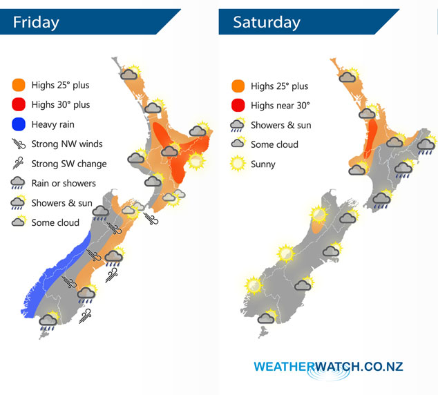
A cold front pushes northwards over the South Island today, weakening as it goes. A ridge lies over the North Island with the aforementioned front arriving about the lower North Island overnight. A ridge of high pressure pushes in over the South Island on Saturday meanwhile a southeasterly airflow lies over the North Island.
A northwesterly airflow lies over the North Island today, expect some cloud in the west with sunnier conditions out east. There may be a light shower or two this morning for Taranaki and Kapiti then overnight further rain or showers moves in. Rain pushes northwards along the West Coast of the South Island, heavy about South Westland but easing as it moves northwards. Gusty northwesterlies in the east but a cool southwest change moves in bringing rain or showers to Southland and Otago in the morning then Canterbury in the afternoon.
Showers for the eastern North Island on Saturday, drier out west however a late afternoon / evening shower is possible from Bay Of Plenty through to Northland. The South Island has mostly sunny weather however there may be some early morning cloud in the east, perhaps an early shower for Southland also then clearing.
By Weather Analyst Aaron Wilkinson – WeatherWatch.co.nz
Comments
Before you add a new comment, take note this story was published on 31 Jan 2019.
Latest Video
Hot & dry for many + Tropical Cyclone potential next week near Solomons/Vanuatu
The first tropical cyclone of the South Pacific Cyclone season may be forming next week well north of NZ with…
Related Articles
Hot & dry for many + Tropical Cyclone potential next week near Solomons/Vanuatu
The first tropical cyclone of the South Pacific Cyclone season may be forming next week well north of NZ with…
Drier weather returning, warmer too + some tropical trouble brewing
High pressure is moving closer to NZ today, pushing away yesterday’s downpours and thunderstorms well offshore east of the country,…
Large low today, hit & miss downpours / thunderstorms + your weekend outlook
A large low pressure system is bringing unstable weather conditions to most of the North Island today, resulting in downpours,…


Add new comment