High pressure crosses NZ this weekend ahead of the next low
22/02/2018 11:41pm

> From the WeatherWatch archives
New Zealand will be under a ridge of high pressure this weekend, with it mostly focused on the North Island bringing settled weather and increasing warmth.
Strong winds are not expected in most areas and sunshine is expected in most major cities, such as Wellington, Auckland and Christchurch.
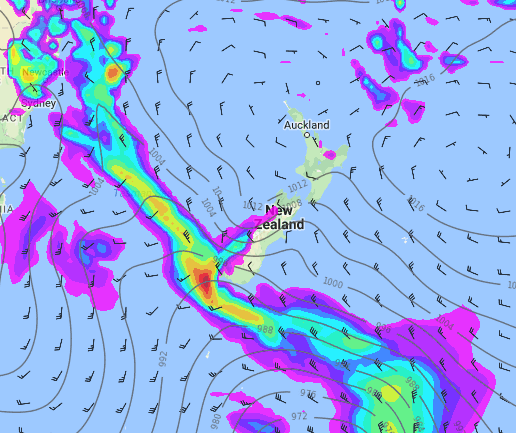
However, a developing low will approach the South Island on Sunday, partially fuelled by the remnants of Cyclone Kelvin which is today exiting Australia over the Great Australian Bight.
In New Zealand it will continue to be mostly sunny in the North Island both Saturday and Sunday (with a few cloudy areas) but rain will start on the West Coast into Sunday. At the same time strong winds are also expected ahead of this developing low on Sunday, mainly in the South Island and around the Cook Strait. Gales are possible through the southern half of the Southern Alps.
It will rain in the South Island on Monday and localised heavy rain will be possible in the west and even the south.
Maximum temperatures will be 20-24C in major cities today and tomorrow.
It will be above 25C in some areas of the both islands on Sunday due to a warm flow from the north with Hawke’s Bay getting into the low 30s on Sunday. Temperatures will turn cooler on Monday behind the cold front, and will be below 20C in most areas of the South Island.
4PM SUNDAY TEMPERATURE MAP:

4PM SUNDAY FORECAST RAIN RADAR:
– Maps / Weathermap.co.nz
– WeatherWatch.co.nz / The Weather Company
Comments
Before you add a new comment, take note this story was published on 22 Feb 2018.


Add new comment