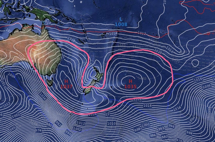
High pressure continues to dominate NZ next week, even our rain forest, Fiordland, is dry, dry, dry.
18/06/2020 7:50pm

> From the WeatherWatch archives
The forecast for the wettest part of NZ is completely dry for a week ahead. It’s a rare set up for Fiordland, a national park, a rain forrest and one of the wettest places on the planet.
More enormous high pressure is to blame – or thank – depending on who you ask. While Fiordland can get nice dry spells from time to time, this one is particularly prolonged and at a time of year well known for wet weather there.

The incoming high is roughly shaped like a U or weird smiley face and stretches from inland Australia, over Sydney, down to Fiordland and Southland, then out to the Chatham Islands and then balloons out towards Rarotonga in the coming days. It covers thousands of kilometres across and will bring a rare extended winter dry spell to the lower South Island – in fact much of the South Island.

But the shape of this high (which is really two highs east and west of NZ that are now merging/linking just south of Southland) means northern NZ has a very different set up, milder airflows, more cloud and a higher risk of showers. Currently a weak low is helping fuel that – but next week the shape of this high encourages more showers here and there.
This set up means frosty weather returns to the South Island’s interior, while the North Island will have showers in the north and milder easterlies. You can read more about this here.
This map, from the US Government, shows lower South Island rainfall will be less than 5% of normal or this time of the year. A couple of locations in the North Island lean wetter than average, which is a positive for remaining dry areas. This maps covers from this Friday to next Friday.

Showers will continue into some of the driest parts of the North Island too.
Rain – possibly with sub-tropical connections – returns to Fiordland and other parts of NZ around Sunday June 28 (Give or take a day or so). At that point there may be a break in high pressure over New Zealand for a few days – but yet to be locked in.
For more daily data in your local spot – including barometric pressure, dewpoint, frost and fog forecasters – please visit www.RuralWeather.co.nz
Comments
Before you add a new comment, take note this story was published on 18 Jun 2020.


Add new comment
Peter Thomas Langer on 18/06/2020 11:10pm
fiordland well its been having too much rain lately and things need to even out….theres still no high over aus like its surpose to do in winter
Reply