Heavy frosts in the south – Your Weather Highlights for the next 3 days
7/08/2016 7:00pm

> From the WeatherWatch archives
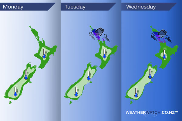
Today sees a southerly airflow cover most of New Zealand, although it’s relatively weak. Some cloud and the odd shower in the east from Banks Peninsula northwards (more so near the coast), and heavy frosts morning and night inland for the South Island. A few showers on Tuesday about the east and north of the North Island. Dry in the west from Waikato southwards, and the South Island has a ridge of high pressure. A similar pattern continues on Wednesday.
Monday
White – Heavy frosts to start the day for the inner South Island; watch for potential black ice on the roads. The inner North Island, while also having a frosty start, will likely not be as cold.
Tuesday
White – Heavy frosts once again for the South Island, a little more widespread this time. Once again, while the inner North Island will be frosty, it may not be as cold as the inner South Island.
Blue – A low pressure system moving from west to east over northern Northland during the day brings a spell of rain for Northland which may be heavy, especially in the east.
Purple – Gusty southeasterly winds are also likely but at this stage, winds are not looking to be a gale but they may gust close to gale at times in exposed coastal areas.
Wednesday
White – Another frosty start for the inner South Island, however not as cold as the past few days. The inner North Island may only just dip down to 0 around dawn.
Blue – Tuesday’s low hasn’t moved much and may bring some heavy rain to northern parts of Auckland / Northland during the day.
Purple – Winds remain gusty from the southeast.

– Please note, the idea behind this update is to focus on the main weather highlights, which is why not all regions are mentioned.
For specific 10 day information for your city, town, rural community or island please see the 1000 forecasts on our homepage!
– Aaron Wilkinson, WeatherWatch.co.nz
Comments
Before you add a new comment, take note this story was published on 7 Aug 2016.


Add new comment