Gales for Australia but what about New Zealand? (+9 Maps)
10/05/2018 11:06pm

> From the WeatherWatch archives
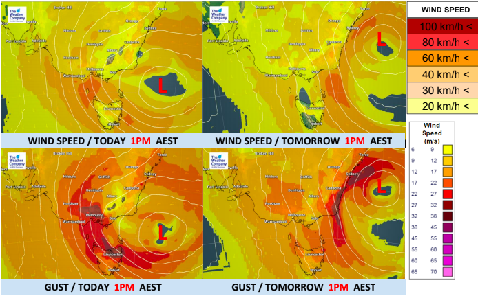
With a deep and large low near south eastern Australia expected to produce severe gales there many are curious if they will hit New Zealand too. The system is complicated but can be explained fairly simply when it comes to the winds.
Basically there are three areas of wind:
- Wrapped around the Main Storm itself out at sea nearer to Australia at the moment.
- In the Squash Zones (windy areas between the centre of the low pressure and nearby highs)
- A small secondary low that is spinning off towards the South Island today
1) Main Low itself. This is the large low nearest to Australia and these severe winds will NOT be impacting New Zealand on Friday, Saturday, Sunday or Monday. It will reach New Zealand on Tuesday and cross the South Island on Wednesday entirely falling apart based on modelling today.
2) The squash zones. These severe winds near Australia will be made even stronger by an incoming high to their west, creating for a very strong southerly blast. In New Zealand we have a different ‘squash zone’ between this low near Australia and the departing high to our east. Most of the winds over New Zealand next few days will be caused by the back end of this departing high (encouraging warmer than average sub-tropical north to north east winds merging with the nor’west flow from the Tasman Sea low – that’s why we’re expecting heavy rain in northern NZ).
3) The small secondary low today is short lived and will fall apart later today and tonight over the lower half of the South Island.
TO RECAP:
The worst winds will be in south eastern Australia. New Zealand may have some strong winds for a time, especially around some of the downpours. Power outages are not generally in our forecast although we may get a few isolated cuts across the country here and there. For the most part New Zealand’s winds look below damaging.


– WeatherWatch.co.nz – Proud to be an official IBM business partner
Comments
Before you add a new comment, take note this story was published on 10 May 2018.


Add new comment