Fairly mild again mid next week as windy westerlies return (+3 Maps)
5/08/2021 10:35pm

> From the WeatherWatch archives
Yes a winter blast is coming, yes it will feel like mid-winter, yes it is mid-winter, no it won’t linger. Monday is peak cold across New Zealand with serious wind chill (-15C at Mt Hutt and -3C in Timaru for example) but quickly after this cold blast comes the westerlies.
The milder windier westerlies – often considered more of a sign of a spring-like pattern – look to be frequently dominating New Zealand over the next couple of weeks. It won’t always be mild but there is a good variety of mild days in a row with shorter bursts of cold.
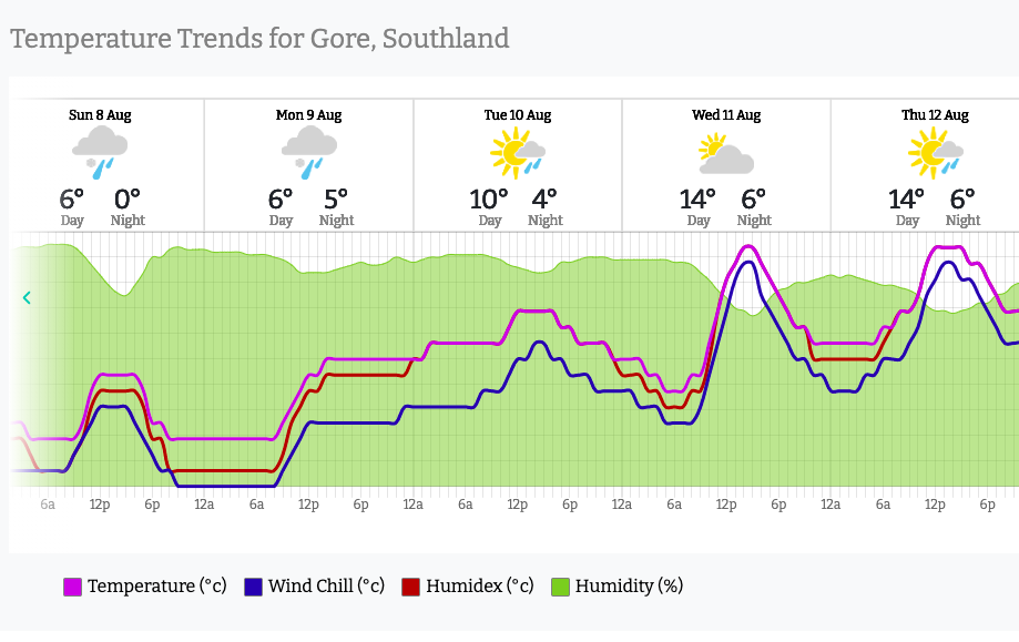
In the short term, take a look at the temperatures bouncing around from Sunday to mid next week…
- Daytime highs in Southland go from around +5C to +7C on Sunday and Monday to +12 to +14C by Wednesday.
- Timaru goes from +6C on Sunday to +15C by Thursday.
- Waiouru goes from +1C on Monday to +8C by Wednesday.
- Hastings goes from a high of +8C on Monday to +16C by Thursday.
- Auckland goes from a high of +11 on Monday to +14 by Tuesday and +15 by Thursday.
Overnight lows are also going to lift later next week (after some tough frosts first thing) with windy weather limiting frosty conditions in the South Island by mid week.
See the rollercoaster ride of upcoming temperatures by viewing the HOURLY hyper-local WeatherWatch forecasts or visit www.RuralWeather.co.nz (where you can also see wind chill and wind gusts for your specific part of NZ).


Comments
Before you add a new comment, take note this story was published on 5 Aug 2021.


Add new comment