Dry week for most, but southern lows may spark northern rain next week (+4 Maps)
10/01/2021 7:04pm

> From the WeatherWatch archives
High pressure dominates the NZ area until Friday, then we see a change which runs through next week too.
As WeatherWatchh.co.nz has been highlighting since mid November 2020, the Southern Ocean’s weather pattern has been particularly unsettled and this will continue to provide the occasional cool change for the South Island, along with some wet weather.
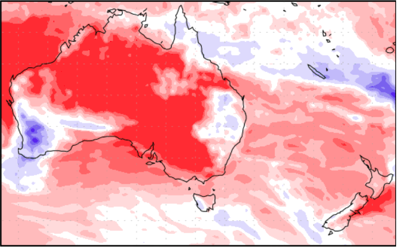
This week drier than average weather expands across most of NZ, the Tasman Sea and much of Australia. It doesn’t look like the usual La Nina set up, except for the heavy rain around some tropical islands to our north and a little in eastern Australia.
On Thursday a low does drop out of the sub-tropics to our north east and brushes East Cape and Gisborne. It’s worth monitoring because it is a sub-tropical low packed with moisture, but it’s looking likely that high pressure over NZ will guide it east, keeping it mainly or completely out to sea. One for the surfers to monitor especially!
Humidity on Friday may see a few afternoon downpours in the South Island.
This Weekend a low brushes the lower South Island then deepens over the Southern Ocean. It may bring gales, rain and a likely temperature drop – one to monitor this weekend into the start of next week.
Next week – a repeat performance around next Wednesday with another southern low and another cold injection to the south, but North Islanders you do have a chance of some wet weather next week from this southern system. Some modelling suggests high pressure will clear enough to allow rain or some heavy downpours to move in nationwide, from the west. This is still 9 days away so definitely not yet locked in, but possible.


Red = Drier than average, White = Normal rainfall, Blue – Wetter than usual
(US GOVT)

Comments
Before you add a new comment, take note this story was published on 10 Jan 2021.


Add new comment
Peter Thomas Langer on 10/01/2021 10:41pm
well it better we havent had any justice yet all the rain is by passing us what a cheek we are heading for our third dry jan in a row
Reply