Cook’s rain pushes into Dunedin, strong winds mostly at sea now
14/04/2017 4:40am

> From the WeatherWatch archives
Final Update 4:40pm — The low that used to be Cyclone Cook is now centred east of Dunedin and is tracking southwards along the coastline but well out to sea. The peak winds are easing around the centre and the majority of these strongest winds are 150 to 200kms out to sea and will likely remain there.
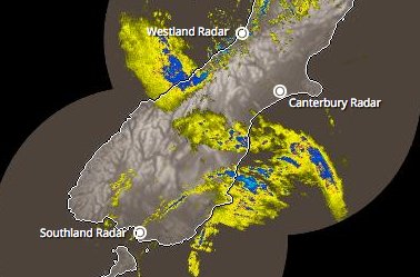
However the heavy rain associated with Cook is pressing into some parts of the eastern side of the South Island. The rain clouds have fractured a lot overnight as the North Island land mass and the ranges of the South Island impact the low itself.
Rain in Dunedin is set in with the chance of some flooding – but at this stage we’re optimistic it won’t be at the extreme end, but be vigilant around streams and watch for surface flooding on roads. Some heavier downpours are possible and this could put pressure on rivers and streams already running high. Conditions will ease overnight.
Meanwhile in the North Island the westerly flow behind Cook is pushing in with plenty of small showers heading in to the west and north, plus clear spells. It’s fairly mild. Some showers are heavy, especially around Waikato and Auckland region.
Over the weekend the main low that was Cook will depart into the Southern Ocean while a small, weak, low (triggered by the remnants of Cook and the Tasman low) will move back up the West Coast and yet again towards the western North Island bringing cloud and further downpours on Sunday and early Monday for a time.
 – Image 4:30pm rain radar image, courtesy of the NZ taxpayer and Government
– WeatherWatch.co.nz
Comments
Before you add a new comment, take note this story was published on 14 Apr 2017.


Add new comment
Guest on 14/04/2017 4:54am
If you look at the Dunedin webcams, it looks like it’s improved a lot. It’s a pity that Metservice don’t look at some places before they do their updates, to see if their model forecasts are actually correct!
Reply
Zelda on 13/04/2017 11:00pm
Looks like the SI has sprouted wings, with the tail dragging off shore.
Great to see an up to date image courtesy of NZ Tax payers
Reply