> From the WeatherWatch archives
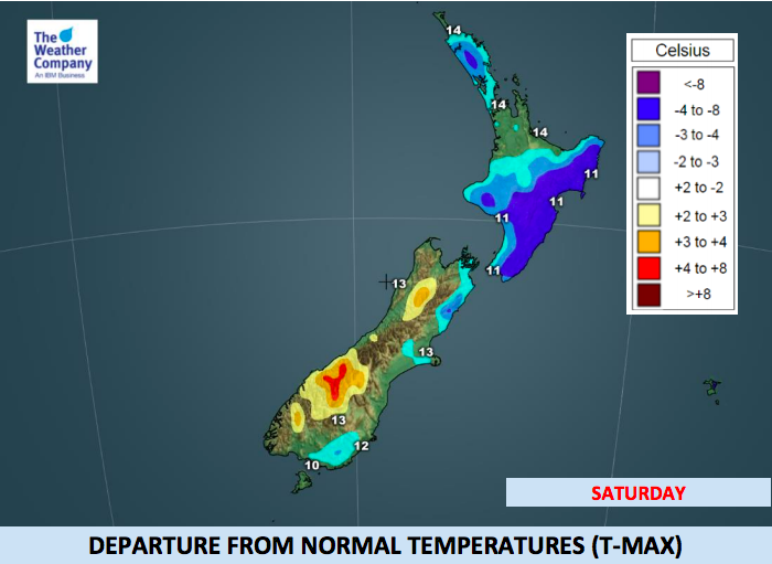
Updated 11:34am to include 3 new Maps — It’s colder than average across a number of regions today as the main southerly flow covers all of New Zealand. However, already the South Island is starting to warm up a little. Places that had single digit highs yesterday are likely to make it to the teens today.
By next week many parts of New Zealand will enjoy temperatures above average with highs from the lower South Island to the upper North Island reaching the late teens and even the early 20s. An enormous high pressure system in the Tasman Sea will take the next 10 days to slowly move across the New Zealand area bringing drier than average weather to most places – and a warming up effect.
SOUTH ISLAND BY DAY:
Let’s take Northern Southland to begin with. Yesterday the area had snow showers and wintry single digit temperatures. By Monday the high is 14, then 16 middle of the week, then potentially 20 degrees by Friday.
Queenstown is similar. Yesterday snow fell there, by the end of next week temperatures around 20C are possible. Dunedin has highs in the mid to late teens possible next week too. Christchurch may reach 20 degrees as early as Wednesday and Wellington will have afternoon temperatures several degrees warmer than today by Tuesday.
Nelson is so sheltered from this cold snap they are mild this weekend then reach late teens and early 20s into next week. Marlborough reaches early 20s mid next week.
The West Coast is the only exception due to SW winds off the Tasman and Southern Ocean. You have a warm Sunny Sunday on the way…but next week looks showery and cool…until late week when you warm up to the mid teens.
NORTH ISLAND BY DAY:
In the North Island today, Saturday, is the coldest day of the week for most as the main southerly moves in. However warmth creeps back on Sunday and by Monday most places will be in the mid to late teens with the 20 degree mark likely to be reached in a number of regions next week, especially the eastern North Island – like Hawke’s Bay.
Like the South Island the western North Island also has a cooler period of weather next week due to the airflow coming from over the sea. Highs mid week may only reach 15 degrees in New Plymouth but 18 by Friday.
Even Taupo has a high of 18 degrees on Tuesday with sunny skies with 20 degrees possible by the end of the working week.
OVERNIGHT ACROSS NEW ZEALAND – Frosts possible:
With the main southerly change now across the country and a building high to the west it means as winds ease and skies clear temperatures will drop a lot overnight. Across both main islands the overnight lows tonight will be below average with frosts possible in sheltered inland areas (check your local overnight temperatures, anything below +2C has the risk of a frost if winds are light and skies are clear).
Central Otago, inland Canterbury and King Country appear to have the highest chances of frosts tonight/Sunday morning – and again on Sunday night/Monday morning.


– WeatherWatch.co.nz
Comments
Before you add a new comment, take note this story was published on 12 Oct 2018.


Add new comment