Cold again tonight, then a late week warm up coming, with a wintry change next week!
22/06/2021 7:43pm

> From the WeatherWatch archives
NZ has one last cold night tonight before a warmer airflow kicks in and lifts overnight temperatures several degrees above average for some regions as we head into the weekend.
A southerly change faded out yesterday bringing the frost risk this morning as far north as Auckland – and potentially again tonight.
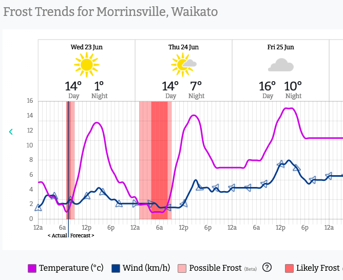
Tonight is a repeat performance for the North Island in particular, with overnight lows in the low single digits for many and sub-zero across parts of Waikato. The Frost Forecaster at RuralWeather is already highlighting a few examples below…


But warmer weather is coming, as high pressure departs and a cold front moves in – the combination will create for windier nor’westers to move up NZ bringing more cloud and extra warmth.
Overnight lows by Friday night will be 4 to 8 degrees above normal in the areas below shaded in red.
It’s not just overnight lows that will lift, daytime highs will too. Hastings in Hawke’s Bay has a high of +18C to 20C on Saturday and an overnight low of +14. Not bad for a few days after the winter solstice.
But in winter, nothing lasts for long – with the next cold change scheduled for early next week. “How cold?” you ask…well…let’s put it this way: Next Monday Dunedin has a daytime HIGH of just +5C and by Tuesday Christchurch has a daytime high of just +7C. That’s a significantly cold change.


- WeatherWatch.co.nz and RuralWeather.co.nz
Comments
Before you add a new comment, take note this story was published on 22 Jun 2021.


Add new comment