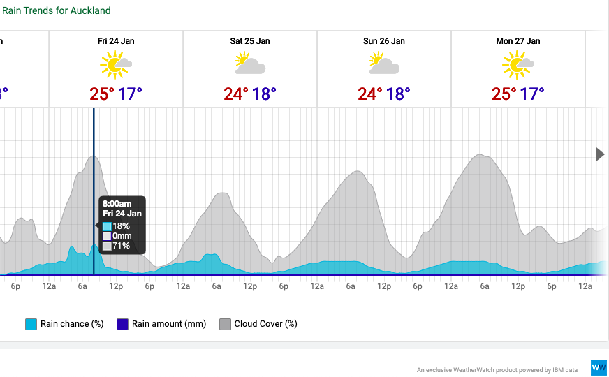
Cloud Graphs: Distinctive dorsal fin shapes reveal daily morning cloud will burn off
21/01/2020 10:40pm

> From the WeatherWatch archives
For those who use the cloud and fog forecasting graphs and data at RuralWeather.co.nz, you may have noticed a pattern forming, with morning cloud then a sunny afternoon.
In some regions it’s a thicker block of grey, indicating plenty of cloud that may take until the afternoon to burn off or break up. But for other centres where the hot sun burns that cloud off faster, you end up with pointy peaks of cloud each morning in our daily Cloud/Fog/Rain graphs at www.RuralWeather.co.nz.
With the example we’ve taken here from Auckland, you can clearly see we’re at that time of year where warm days, plus water surrounding NZ, plus nights becoming longer equals morning cloud. As the sun rises, it burns it off – giving the graph this dorsal fin shape:
FOG
As we saw in Wellington recently, foggy weather in summer can affect flights. In fact, Wellington often has low cloud and foggy events just out around the airport under particular eastern set ups in February and March. Windier weather coming up reduces the chances but morning foggy areas are more likely in the forecasts as we move further into 2020 and the nights slowly continue to get longer.
Canterbury, Wellington and Waikato are high risk candidates for morning cloud and fog – but so too are many surrounding regions.
Our new RuralWeather.co.nz homepage has free CLOUD and FOG products for you to check out/use – either locally, or at airports you may be flying in and out of. The page is especially useful for air travellers, star gazers, or anyone just generally needing to track cloud and visibility levels on the ground.
– RuralWeather.co.nz (Please note: It takes 10 seconds to open all the data on the homepage the first time you visit – we’re working to speed that up this year!)
Comments
Before you add a new comment, take note this story was published on 21 Jan 2020.


Add new comment