Check out the big winter storm tracking south of NZ & blasting us next week (+6 Maps)
21/09/2018 12:26am

> From the WeatherWatch archives
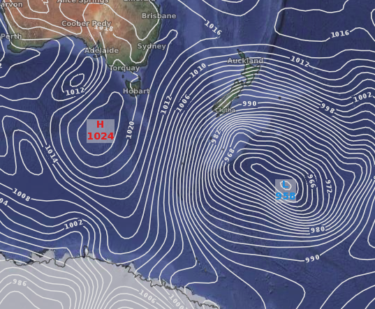
It is a significant storm and it will churn past New Zealand over the Southern Ocean next week, working in conjunction with a high near Tasmania to dredge up a polar blast that will bring snow, possibly to sea level, in the lower South Island.
Latest data suggests snow may fall in Milford Sound and will be very close to sea level in Southland for a time. Lumsden in Northern Southland looks likely to get snow, as will Manapouri, Queenstown, Wanaka, Cromwell and possibly Gore, Alexandra and some parts of Dunedin higher up. The angle of the system means those further east and north east (like Canterbury) won’t be impacted by the same cold or wet weather, but Monday looks wintry with snow falling to just a few hundred metres for a time.
The big storm won’t be directly crossing New Zealand, simply grazing us and dredging up this very cold polar air which will mainly impact the lower half of the South Island, especially Southland, Otago, Fiordland and the West Coast.
Snow is also possible in the central North Island. Ohakune, National Park, Waiouru and some parts of Rangatikei may all have snow settle. State Highway 1, the Desert Road, may also have some snow next week (highest risk is Tuesday) but it’s unclear if it will be heavy enough to close the highway.
Queenstown is the coldest of the South Island main centres next week, with single digit highs from Monday to Thursday, warming up a little by day on Friday.
However due to warmer the average soil temperatures in some regions the snow may not settle long and should melt faster lower down.
This late winter storm will bring winter conditions to the lower half of the South Island in particular and will be severe enough to kill newborn livestock due to miserable wind chills and damp conditions which could see the ‘feels like’ temperature drop below freezing even during the middle of the day in exposed farms facing south or south west.


 Wind + Temperature map for Wednesday next week shows the peak of the cold for NZ.
 Snow map for Tuesday. Green = Rain, Red = Snow (orange, yellow, blue = rain/snow/sleet mix)

Snow map for Wednesday next week.

– WeatherWatch.co.nz
Comments
Before you add a new comment, take note this story was published on 21 Sep 2018.


Add new comment