> From the WeatherWatch archives
Mother Nature continues to hammer the Rena salvage with waves of up to seven metres predicted for offshore Bay of Plenty over the next couple of days.
WeatherWatch.co.nz says the dangerous seas are connected to a tropical storm that has close ties with the recent deadly flooding in Fiji.
 Our partners at Weathermap.co.nz say there is still some uncertainty with this incoming low, but sea conditions do look “significant”.
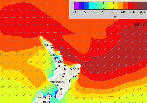
“Latest guidance for the Bay of Plenty offshore area suggests significant wave heights will exceed 4 metres significant Tuesday afternoon, abating Wednesday to three to four metres significant” says Weathermap.co.nz Oceanographer Brett Beamsley
Significant wave height is the average of the top 1/3 of waves.
“Maximum individual waves are expected to exceed 7 metres” .
Mr Beamsley told WeatherWatch.co.nz a short time ago that there is still some uncertainty in terms of wind outcomes from late Tuesday due to the unstable nature of the incoming lows. He says the ultimate wave height will depend in part on these wind outcomes so there is still some uncertainty there.
“Primary guidance suggests south east winds of 30 to 40 knots sustained with stronger gusts for the offshore BOP area from late Tuesday, easing slowly Wednesday… but again note the uncertainty”.
The predicted wind speeds are in excess of gale force.
WeatherWatch.co.nz says surf and rips will be “extremely dangerous” along the North Island’s entire eastern coastline and advises people to stay out of the sea until at least the end of the week, with the weather news authority predicting coastal erosion in more exposed areas.
Image / Swells predicted for Tuesday evening from weathermap.co.nz
– WeatherWatch.co.nz exclusive
Comments
Before you add a new comment, take note this story was published on 2 Apr 2012.


Add new comment
surf2surf on 2/04/2012 7:32pm
The swell has started to pound the Bay of Plenty with some huge waves:
http://www.surf2surf.com/reports/mount-coast
Reply