Auckland Anniversary this weekend + Wellington today: the forecast (+Maps):
22/01/2023 2:14am

> From the WeatherWatch archives
High pressure is dominating – but a cooler change for Wellington is coming and a ‘squash zone’ next weekend is possible for Auckland Anniversary Weekend.
WELLINGTON ANNIVERSARY
Celebrated Monday (23rd) there’s a slightly cooler change coming for the capital itself. Wellington’s daytime high will tumble from 23C or so Sunday, to 18C on Monday (+/- a couple degrees, as more inland areas to the north may not notice the cooler change as much).
Wellington Anniversary covers Manawatu-Whanganui too, where no real change in temperature is expected from today to tomorrow, but winds may ease a little on Monday if they are blowing today.

AUCKLAND ANNIVERSARY
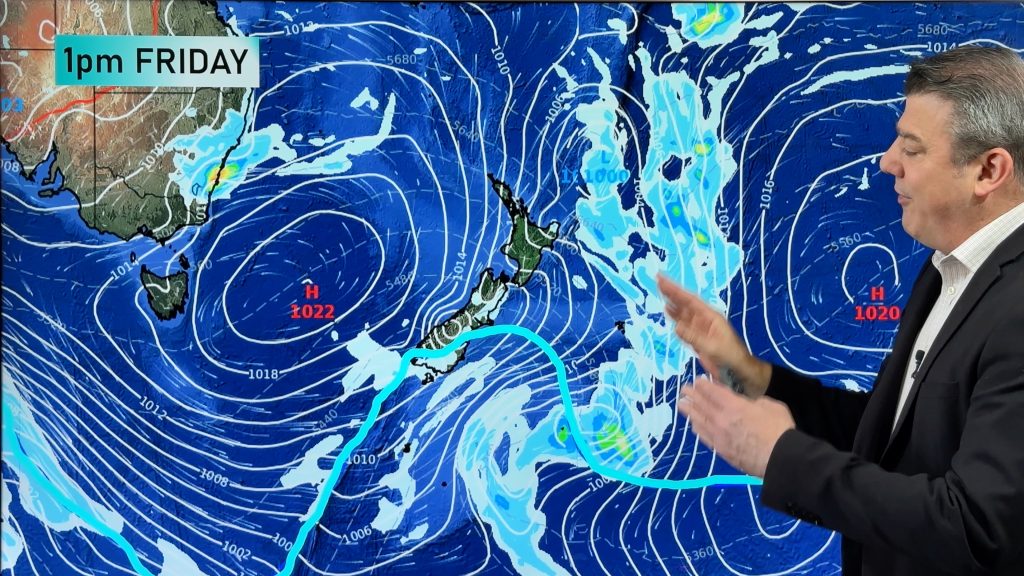
The three day weekend next weekend – which generally covers the top half of the North Island and therefore half of NZ’s population – looks likely to occur during a time of windier, cloudier (and wetter for some) weather as the large high in charge of our current weather pattern lies further east of the country.
This placement of high pressure to NZ’s east encourages a stronger nor’east wind flow over the upper half of the North Island. But coupled with the high being quite powerful and a fairly weak but noticeable area of low pressure in the north Tasman Sea, these both put more ‘oomph’ into that airflow.
Speaking of the low, it’s the leftovers of what almost became a tropical cyclone this weekend over New Caledonia. The powerful high over NZ and conditions in between helped stop that storm from developing further – which it could have easily done without the high influencing conditions. Put short, this Tasman Sea low may not be big, but it may easily drag a period of tropical fuelled rain this Friday/Saturday to the very north of NZ (But timing may still change and much may still fall out at sea).
For holiday-makers it means those popular spots may be in for some windier nor’east weather and a chance of some rain … most likely for the starting period of the long weekend. Some modelling shows the high pressure zone drifting back towards NZ by Monday helping ease winds and push away rain bands.
For now there are no severe weather forecasts. If the high strengthens just a little, or doesn’t move as far east as forecast, this more unsettled weather will stay north of NZ. Likewise, if the high weakens or doesn’t drift back towards NZ a little – or – the weak low deepens and strengthens just a little – then gales and some rain may affect more places for longer. Our IBM forecasts update hourly working all these moving parts out.
Marine gales in the upper North Island along with some isolated pockets of rain are likely – but plenty of dry spells for many spots are forecast too.


Do you alter your travel plans next weekend?
Hopefully not! Keep an eye on the 10 day forecasts we have at WeatherWatch.co.nz and RuralWeather.co.nz – they are already reading and crunching all the weather data/maps to work out the most likely conditions for NZ’s largest (by population) anniversary weekend.
And of course – if you’re leaving the upper North Island we have your lower North Island and South Island forecasts too.
Please note, while some shower/rain icons may appear, don’t forget to check % of rain for confidence, and then the total amount of rain expected (ie, if less than 5mm then that is not likely to be a very wet day! 20mm+ might be).
RuralWeather.co.nz may have a more simplistic layout for working out general forecast gusts and when any wet weather might occur. Great for campers, trampers and those with outdoor plans. We want Kiwis to have more tools to better plan ahead – and fewer nasty surprises. It’s also useful for campground owners and event planners to see when peak ‘bad weather’ moments at your specific location may potentially be – and when the good weather is around too.
We’ll have more details in on our next weather video, around noon on Monday.
- WeatherWatch.co.nz – Proud to be a small NZ business and an official IBM partner.
Comments
Before you add a new comment, take note this story was published on 22 Jan 2023.


Add new comment
Gezza on 22/01/2023 9:58pm
Hi Guys – meant to be heading to Mount Maunganui for Auckland Long weekend…forecast looks pretty average and wet.
Is this forecast looking more likely to be locked in with each passing day? And should I be heading to the west coast instead for some dry stuff?
Cheers
Reply
WW Forecast Team on 22/01/2023 10:44pm
Hi Gezza, the forecasts we have for Mount Maunganui update every 60 minutes – while global models update usually every 6 to 12 hours. So yes, each day we have more confidence in the forecast. Our 10 day forecasts (for all NZ locations) now is looking at the long weekend and providing the best thinking on likely rainfall and wind. Fri/Sat look wettest and windiest at this stage.
Cheers
WW
Reply